9/1/21 – NSIDC Arctic Sea Ice as of yesterday
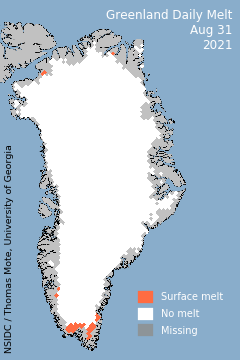
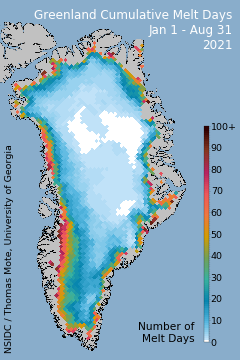
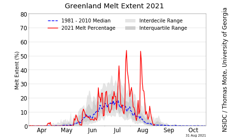
9/1/21 – Greenland Ice Melt as of yesterday
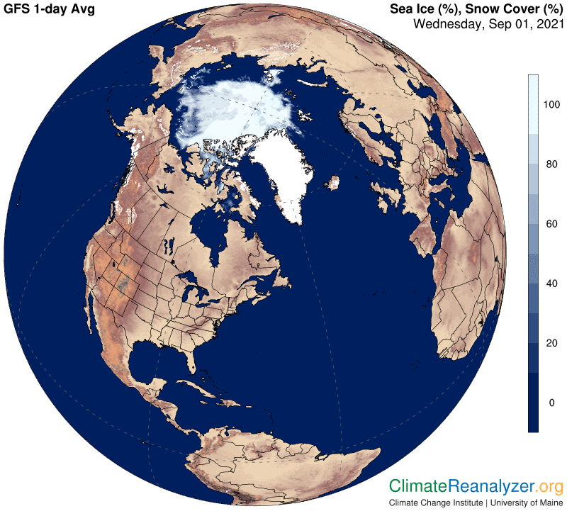
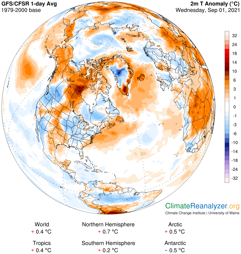
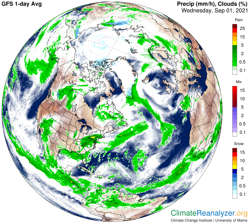
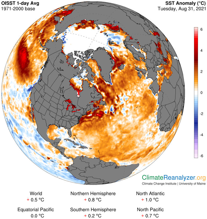
9/1/21 – Here’s the latest Arctic Data from Climate Reanalyzer
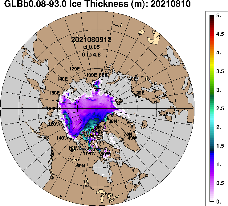
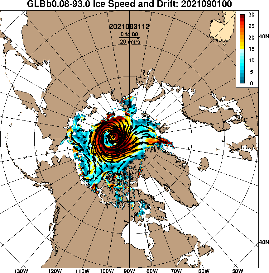
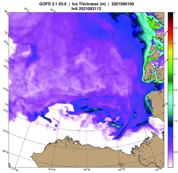
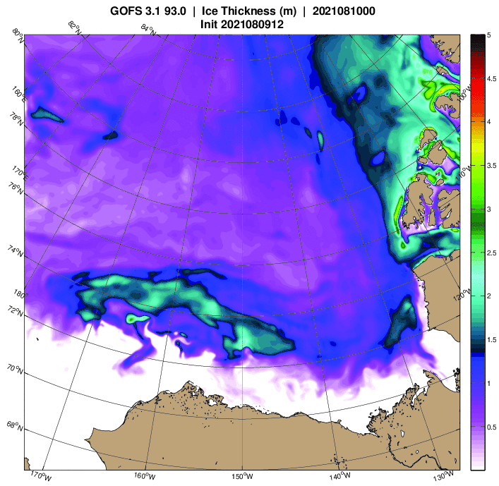
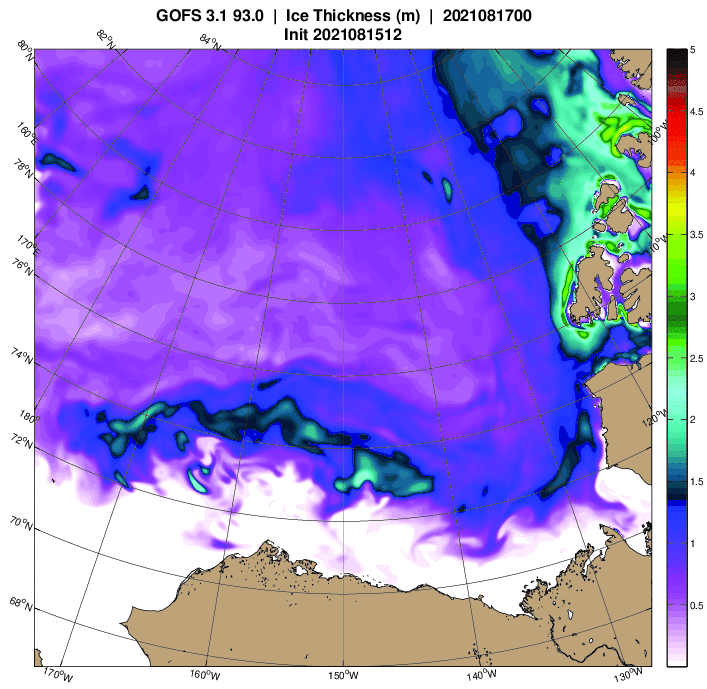
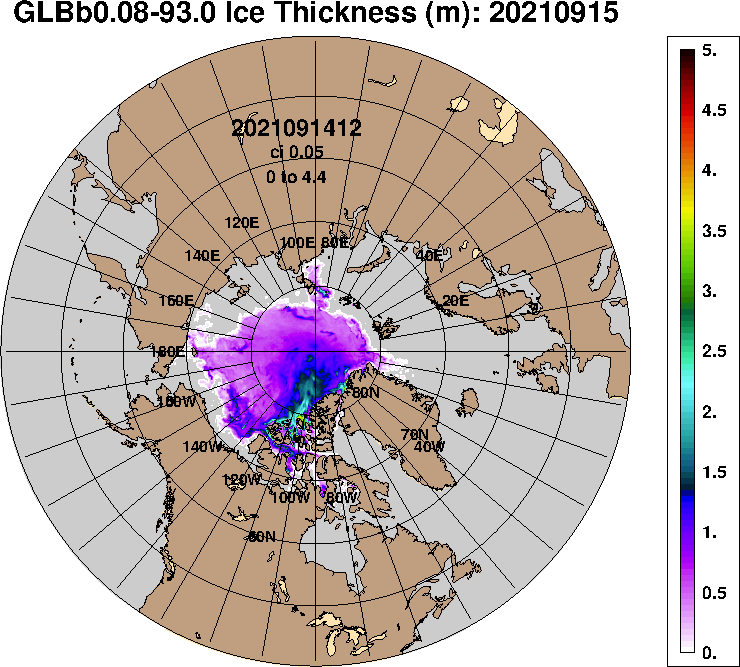
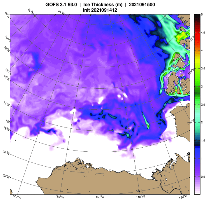
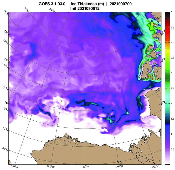
9/1/21 – Here are the latest Arctic Sea Ice Thickness models from the U.S. Navy

9/1/21 – Methane Report for CAMS & NOAA Data for Tuesday, 8/31/21 & Mid-Week Update
Margo goes over how Sulfur Dioxide can either cool or heat up the atmosphere. Margo also reads Hebrews Chapter 12.
Show Link:
https://greenhousemaps.com/learn
9/3/21 – Methane Report for CAMS & NOAA Data for Wednesday & Thursday, 9/1-9/2/21 & Other Updates
Margo also reads Hebrews Chapter 13.
9/4/21 – Methane Report for CAMS & NOAA Data for Friday, 9/3/21 & Other Updates
Margo also reads James Chapter 1.
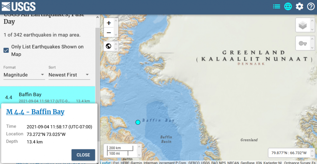
9/4/21 – 4.4 M Arctic Earthquake in the Baffin Bay
M 4.4 – Baffin Bay
- 2021-09-04 18:58:17 (UTC)
- 73.272°N 73.025°W
- 13.4 km depth
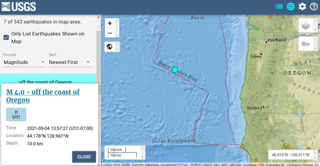
9/4/21 – 4.0 M Earthquake on the Juan de Fuca Plate
M 4.0 – off the coast of Oregon
- 2021-09-04 20:57:27 (UTC)
- 44.178°N 128.961°W
- 10.0 km depth
9/4/21 – from The Barents Observer:
Expedition finds reactors 56 years after dumping
A Russian research expedition has rediscovered the location of the container with two damaged reactors from the Soviet navy submarine K-19, dumped in Ambrosimova Bay in 1965.
Additional to the reactors, about 17,000 objects were dumped in the Kara Sea in the period from the late 1960s to the early 1990s.
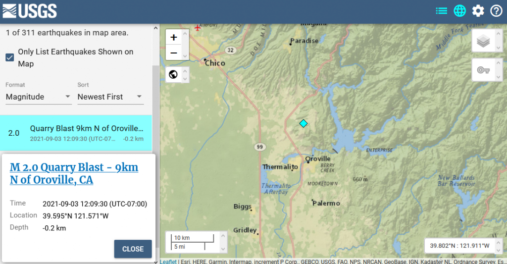
9/5/21 – 2.0 M earthquake from a recent quarry blast near the Oroville Dam
M 2.0 Quarry Blast – 9km N of Oroville, CA
- 2021-09-03 19:09:30 (UTC)
- 39.595°N 121.571°W
- -0.2 km depth
9/5/21 – Looking at the Radioactive Kara Sea, Methane, Sea Ice & Climate Update with Margo (Sept. 5, 2021)
Margo reviews methane data from CAMS & NOAA for Saturday, 9/4/21. She also shows the current state of the Arctic and Antarctic sea ice and looks at Climate Reanalyzer and recent earthquakes. Margo also discusses a recent article on the radioactive waste in the Kara Sea. Margo also reads James Chapter 2.
Show Link:
https://thebarentsobserver.com/en/nuclear-safety/2021/09/expedition-found-exact-location-dumped-reactor
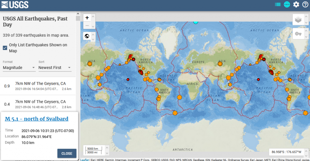
9/6/21 – 5.1 M Arctic Earthquake near the North Pole
M 5.1 – north of Svalbard
- 2021-09-06 17:31:23 (UTC)
- 86.079°N 31.964°E
- 10.0 km depth
9/6/21 – Methane Report for CAMS & NOAA Data for Sunday, 9/5/21 & Other Updates
Margo also reads James Chapter 3.
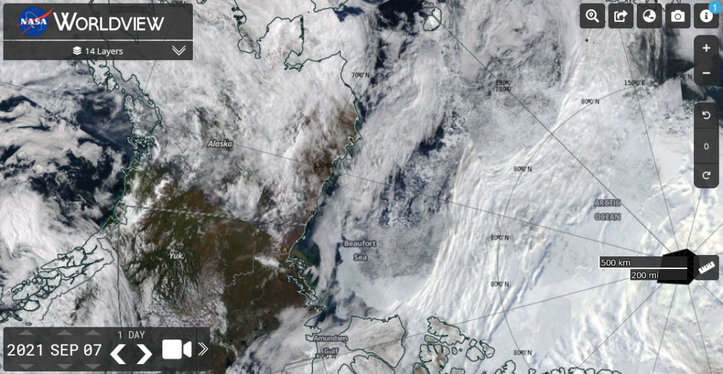
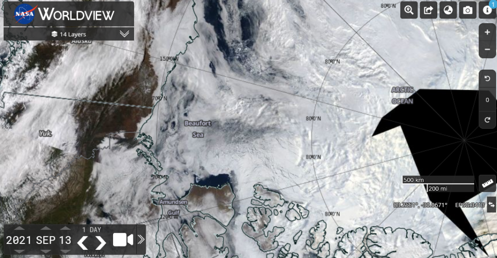
9/7/21 – We can see the collapse of the ice in the Beaufort Sea in this satellite view today
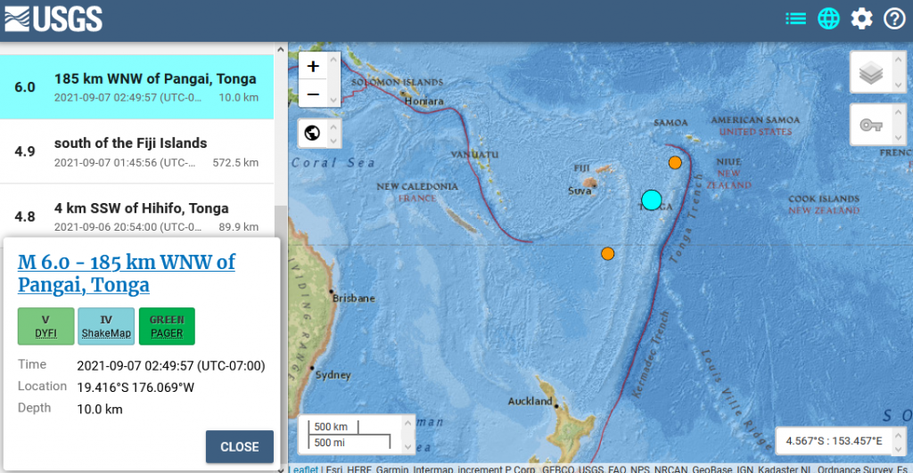
9/7/21 – 6.0 M Earthquake Tonga
M 6.0 – 185 km WNW of Pangai, Tonga
- 2021-09-07 09:49:57 (UTC)
- 19.416°S 176.069°W
- 10.0 km depth
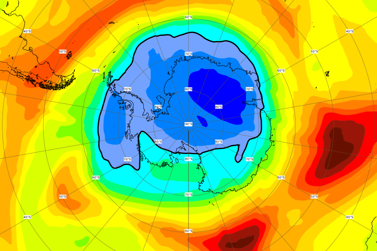
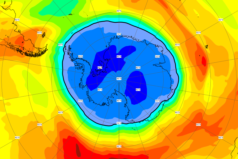
9/7/21 – The ozone hole is growing over the Antarctic with most of the continent in the danger zone
source: CAMS Ozone for 9/7/21, Antarctic View, Total Column
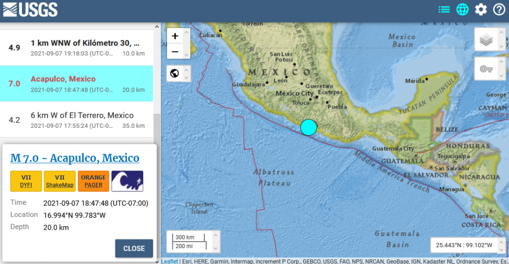
9/7/21 – 7.0 M Earthquake Acapulco, Mexico
M 7.0 – Acapulco, Mexico
- 2021-09-08 01:47:48 (UTC)
- 16.994°N 99.783°W
- 20.0 km depth
9/8/21 – Methane Report for CAMS & NOAA Data for Monday & Tuesday, 9/6-9/7/21 & Mid-Week Update
Margo also reads James Chapter 4
9/8/21 – NSIDC Arctic Sea Ice as of yesterday


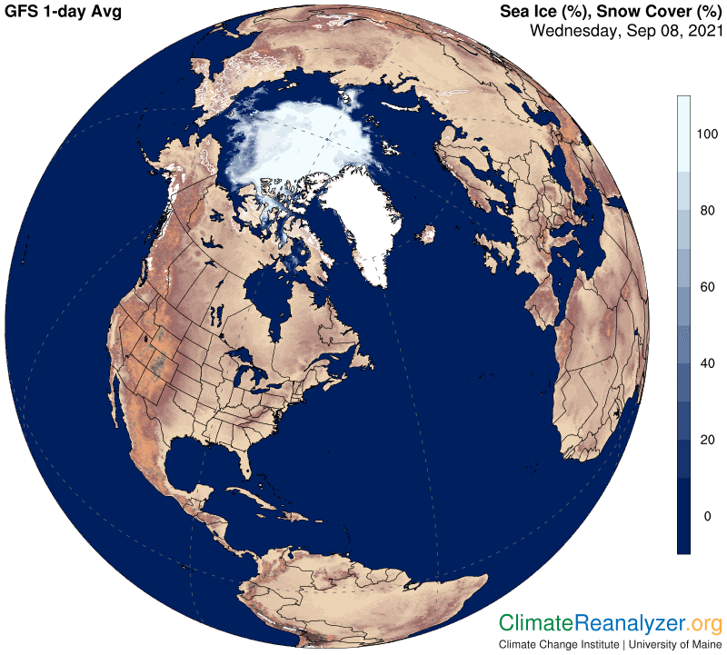
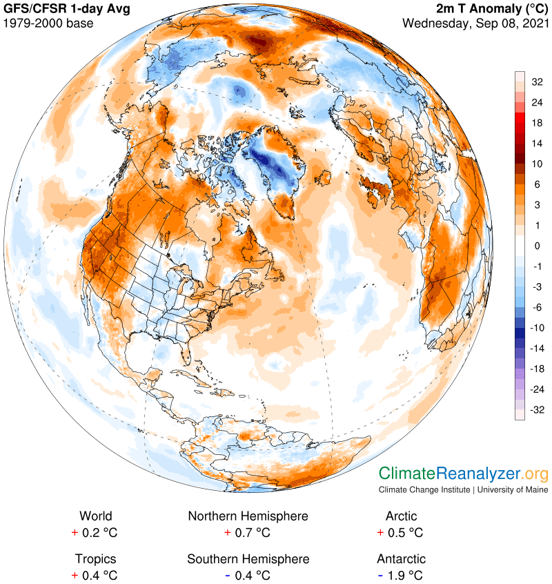
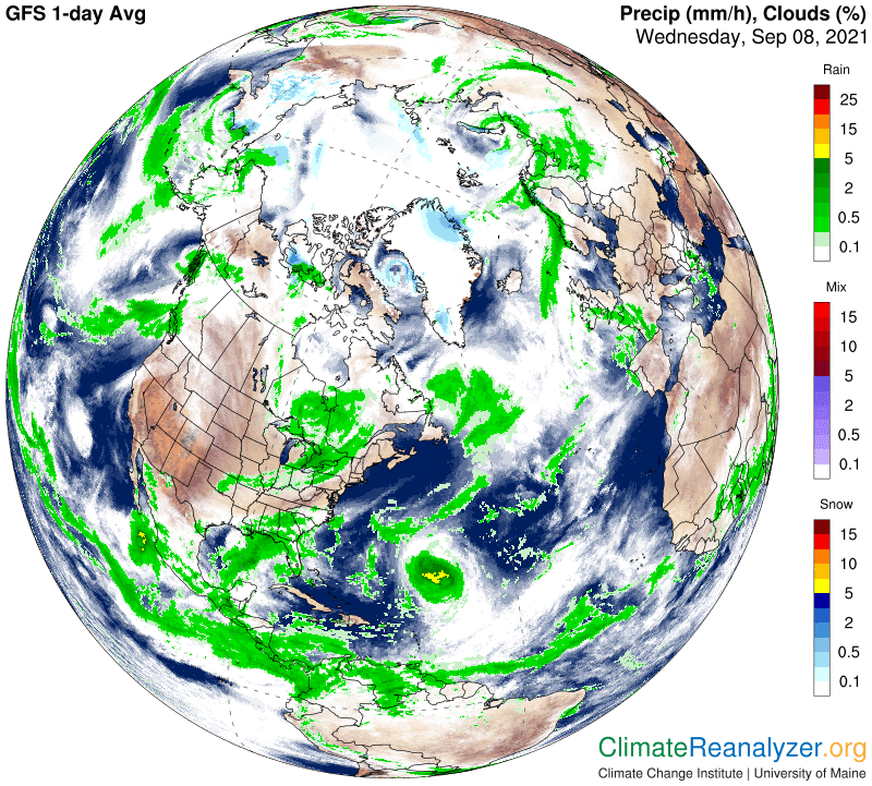
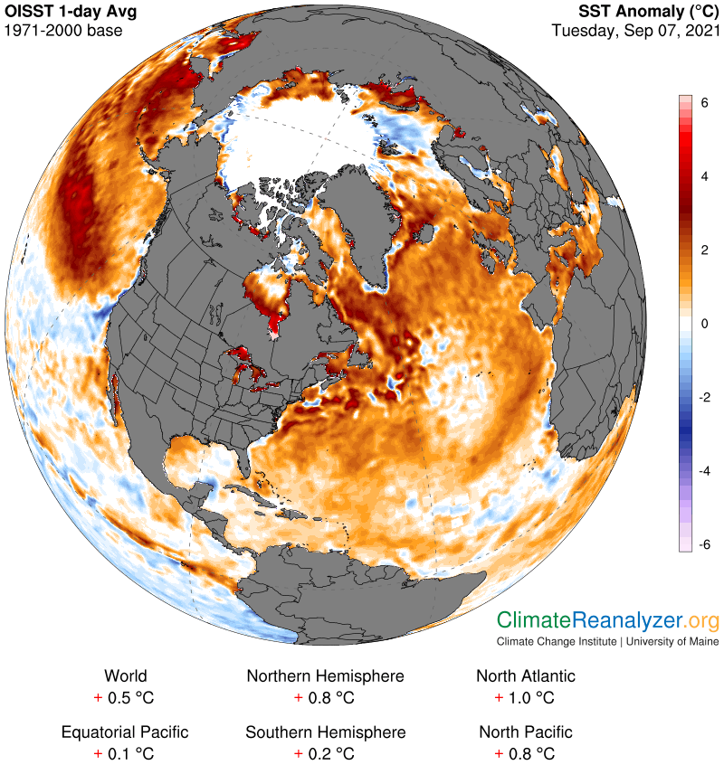
9/8/21 – Here’s the latest Arctic Data from Climate Reanalyzer
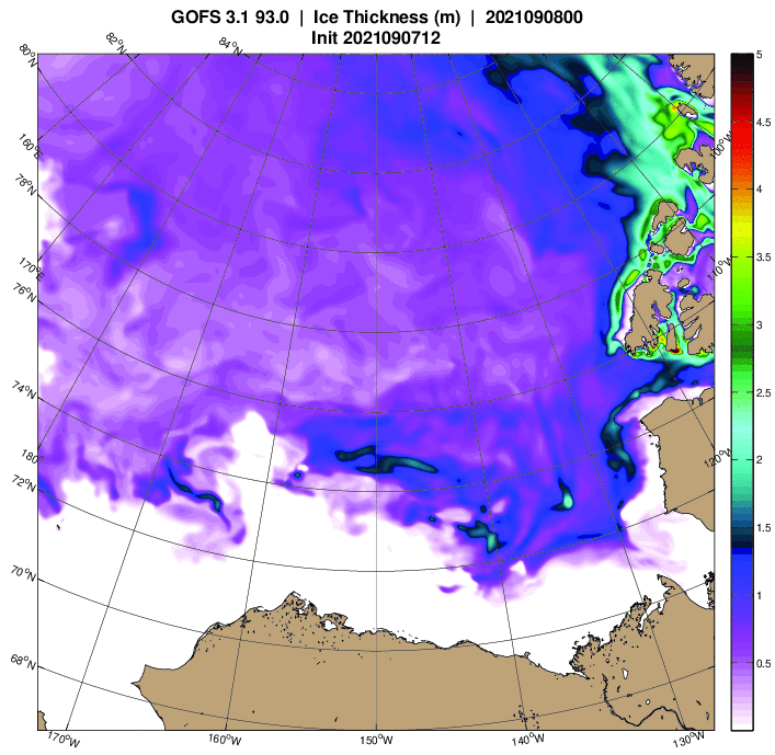
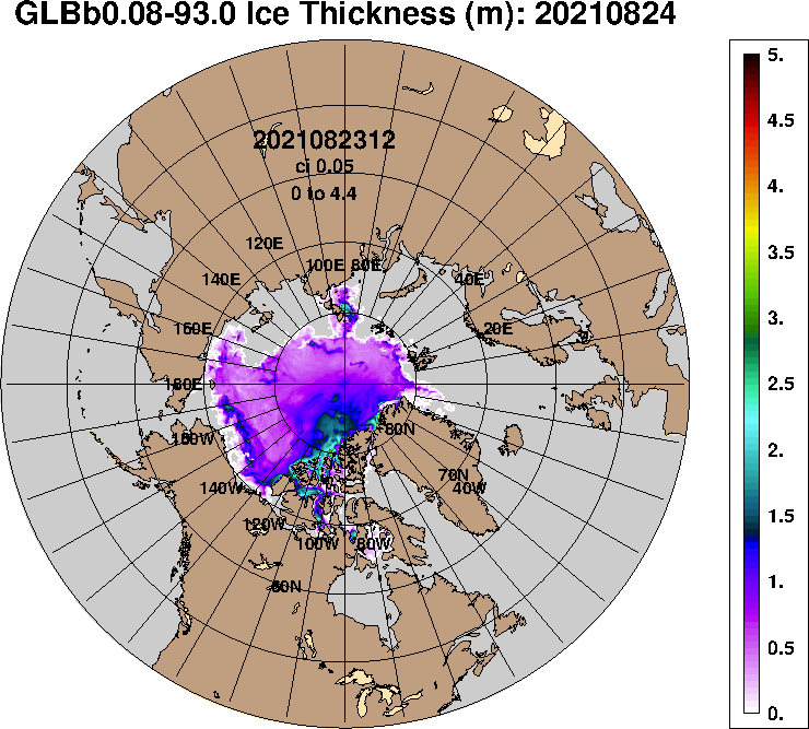
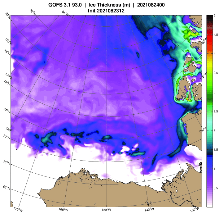
9/8/21 – Here are the latest Arctic Sea Ice Thickness models from the U.S. Navy


9/9/21 – from Jim Massa on Greenland’s melting
9/9/21 – Methane Report for CAMS & NOAA Data for Wednesday, 9/8/21 & Earthquakes
Margo also reads James Chapter 5.
9/9/21 – from the Barents Observer:
First hybrid-electric luxury cruise ship reached North Pole
9/11/21 – Methane Report for CAMS & NOAA Data for Thursday & Friday, 9/9-9/10/21 & Other Updates
Margo also reads 1 Peter Chapter 1.
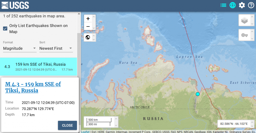
9/12/21 – 4.3 M Earthquake Russia near the Laptev Sea
M 4.3 – 159 km SSE of Tiksi, Russia
- 2021-09-12 19:04:39 (UTC)
- 70.287°N 129.774°E
- 17.7 km depth
9/12/21 – Looking at Hurricane Larry Impacting Greenland, Methane, Sea Ice & Climate Update with Margo (Sept. 12, 2021)
Margo reviews methane data from CAMS & NOAA for Saturday, 9/11/21. She also shows the current state of the Arctic and Antarctic sea ice and looks at Climate Reanalyzer and recent earthquakes. Margo also shows Hurricane Larry’s path to Greenland and Iceland. Margo also reads 1 Peter Chapter 2.
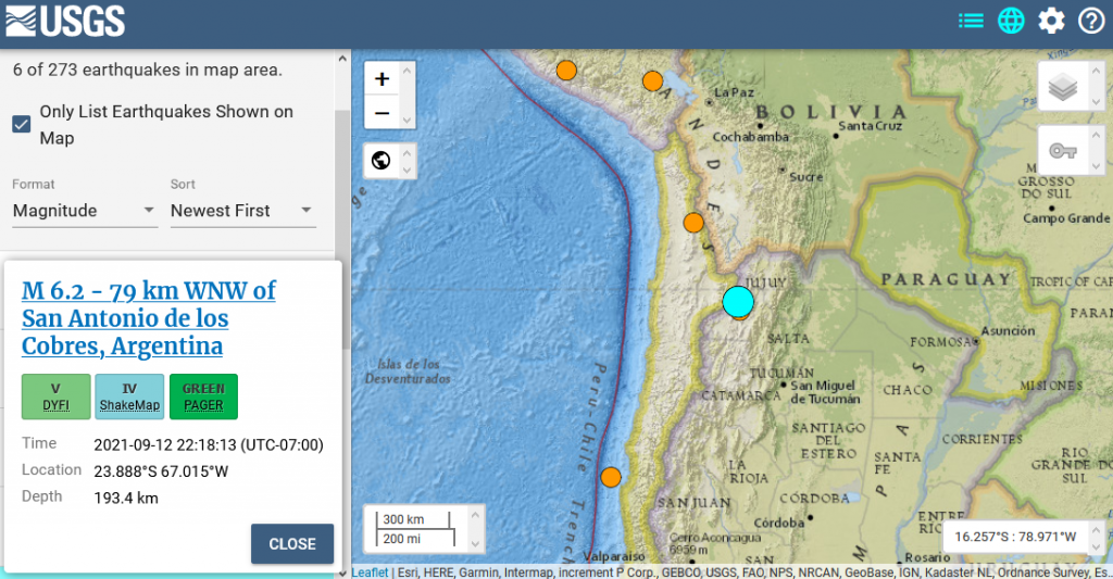
9/13/21 – 6.2 M Earthquake Argentina
M 6.2 – 79 km WNW of San Antonio de los Cobres, Argentina
- 2021-09-13 05:18:13 (UTC)
- 23.888°S 67.015°W
- 193.4 km depth
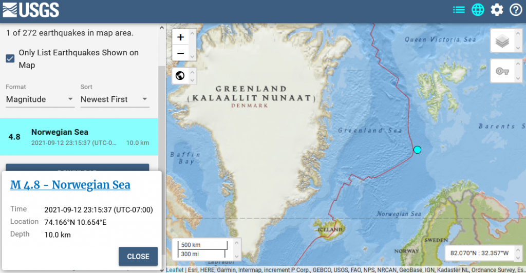
9/13/21 – 4.8 M Arctic Earthquake just south of Svalbard
M 4.8 – Norwegian Sea
- 2021-09-13 06:15:37 (UTC)
- 74.166°N 10.654°E
- 10.0 km depth
9/13/21 – Here’s the ozone hole over the Antarctic today
source: CAMS Ozone for 9/13/21, Antarctic View, Total Column
9/13/21 – There is NOTHING from the USGS on this
La Palma volcano (Canary Islands): strong seismic swarm suggests magma intruding at depth
The strong earthquake swarm is continuing beneath Cumbre Vieja, and now PEVOLCA has raised the alert level to Yellow, citing the repeated occurance of earthquake swarms since 2017, with this one being the strongest and also the shallowest, suggesting magma is slowly rising into the edifice. Measurements of Helium-3 gas flux are also indicating this.
La Palma volcano (Canary Islands (Spain) activity update: Yellow alert for Cumbre Vieja declared
A strong earthquake swarm started under the area of La Cumbre Vieja volcano in the southern part of the Island yesterday. So far, more than 350 tremors have been detected, including 14 quakes of magnitudes above 3.0 and 226 quakes between 2.0 and 2.9.
https://www.volcanodiscovery.com/la-palma/news.html
https://watchers.news/2021/09/13/cumbre-vieja-la-palma-canary-islands-earthquake-swarm-september-2021/
https://www.emsc-csem.org/Earthquake/Map/zoom.php?key=53&typ=euro&min_lat=26&max_lat=36&min_long=-20&max_long=-10&timemin=1630374331&min_mag=2&view=10#2
9/13/21 – Here’s the Beaufort Sea Today
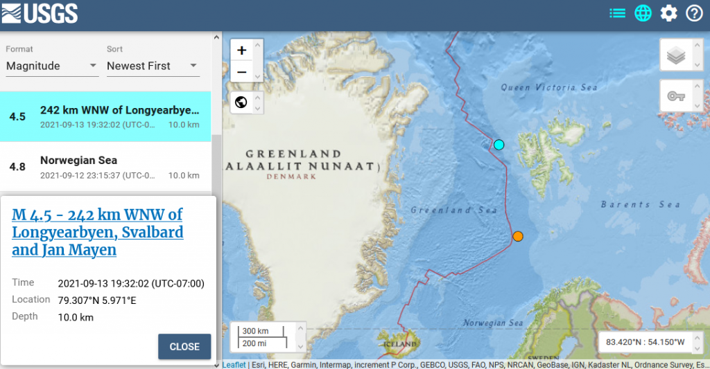
9/13/21 – Another Arctic earthquake near Svalbard – 4.5 M just got posted
M 4.5 – 242 km WNW of Longyearbyen, Svalbard and Jan Mayen
- 2021-09-14 02:32:02 (UTC)
- 79.307°N 5.971°E
- 10.0 km depth
9/14/21 – Methane Report for CAMS & NOAA Data for Sunday & Monday, 9/12-9/13/21 & Other Updates
Margo goes over the new developments at La Palma, Canary Islands. Margo also reads 1 Peter Chapter 3.
Show Links:
https://www.volcanodiscovery.com/la-palma/news.html
https://watchers.news/2021/09/13/cumbre-vieja-la-palma-canary-islands-earthquake-swarm-september-2021/
https://www.emsc-csem.org/Earthquake/Map/zoom.php?key=53&typ=euro&min_lat=26&max_lat=36&min_long=-20&max_long=-10&timemin=1630374331&min_mag=2&view=10#2
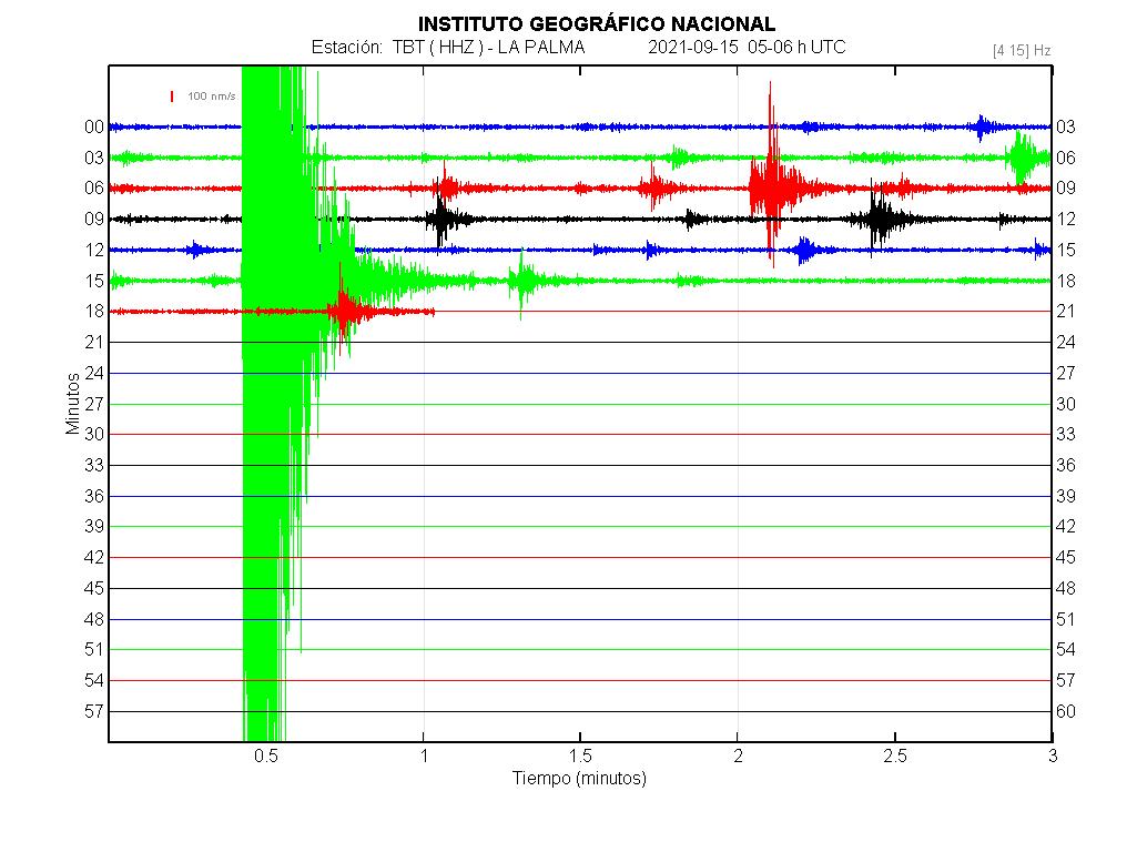
9/15/21 – La Palma volcano update: Earthquakes continue, becoming shallower
The seismic crisis continues with no signs of slowing. More than 250 quakes large enough to be located were detected during the past 24 hours. Minutes ago, a magnitude 3.2 event at only 4 km depth occurred and was felt. This quake can be seen on the seismic trace as the large green signal.
https://www.volcanodiscovery.com/la-palma/news/141424/La-Palma-volcano-update-Earthquakes-continue-becoming-shallower.html
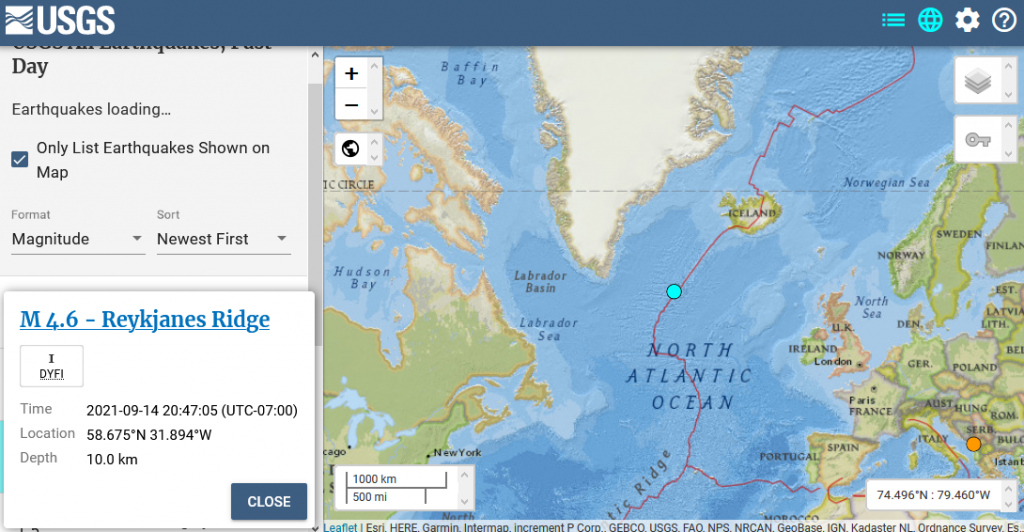
9/15/21 – 4.6 M Earthquake southeast of Greenland
M 4.6 – Reykjanes Ridge
- 2021-09-15 03:47:05 (UTC)
- 58.675°N 31.894°W
- 10.0 km depth
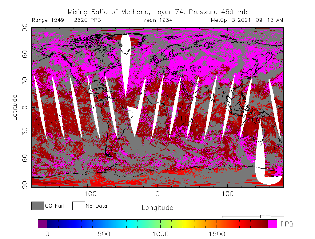
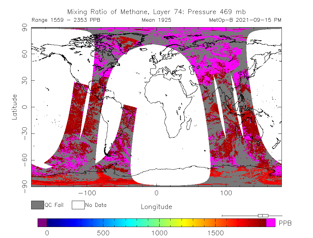
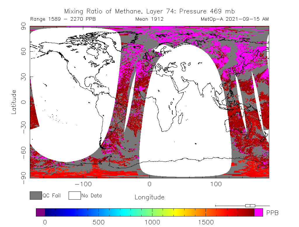
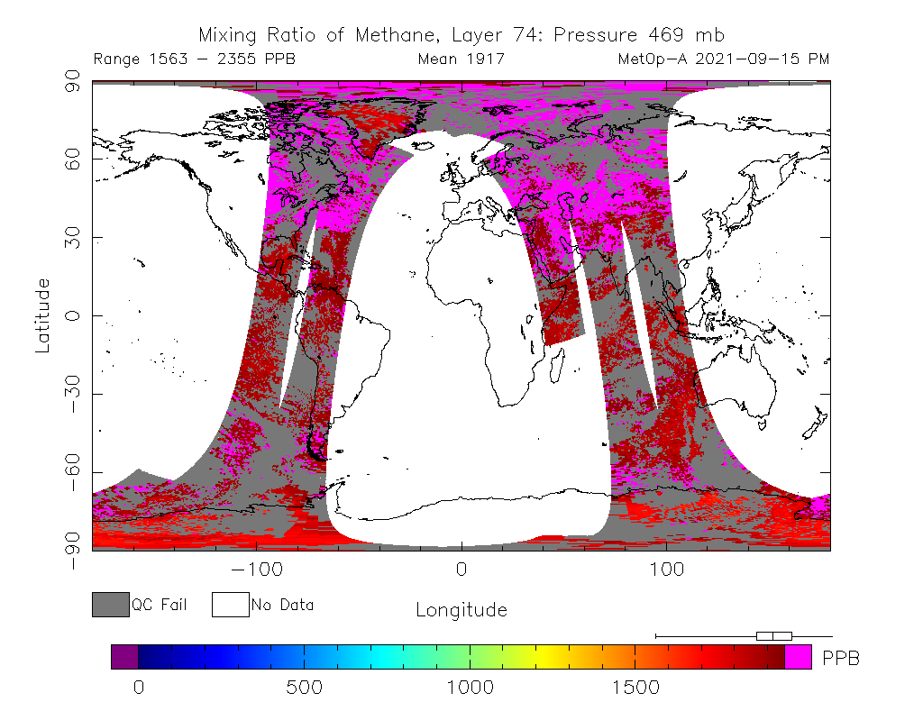
9/15/21 – NSIDC Arctic Sea Ice as of yesterday
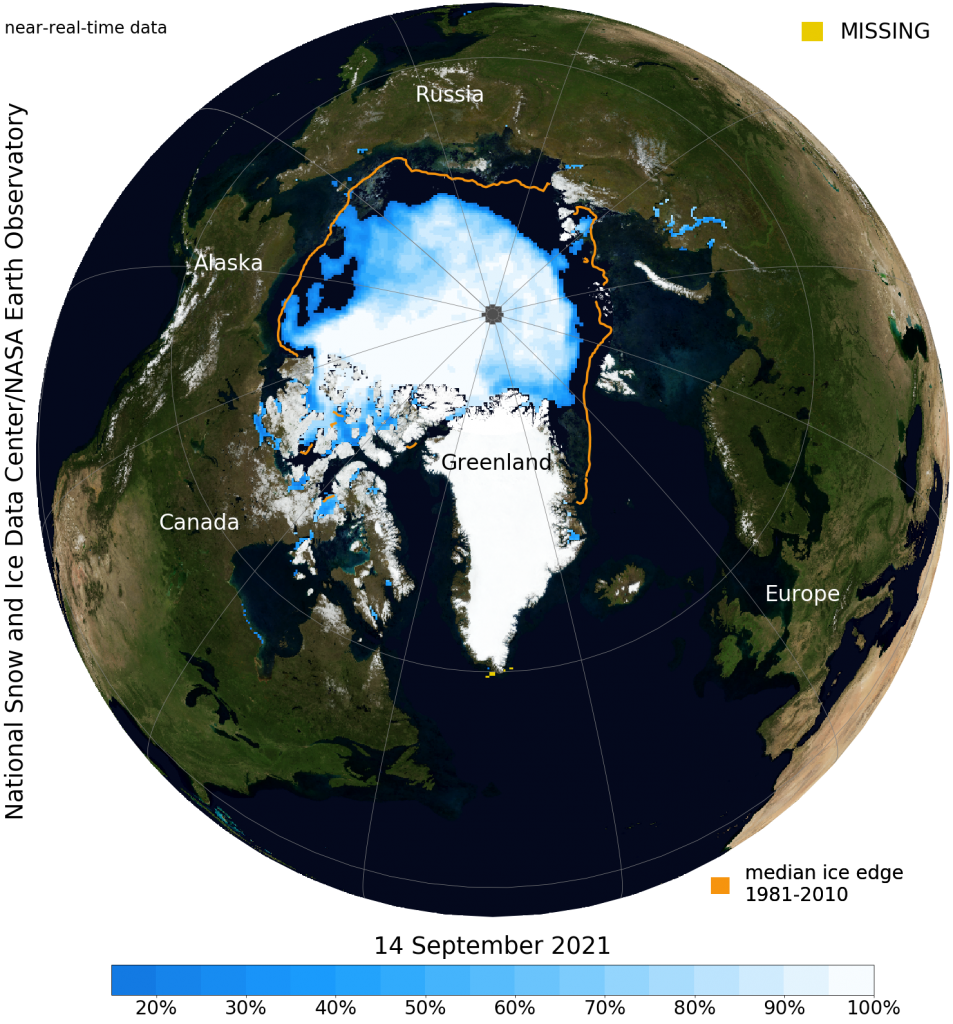
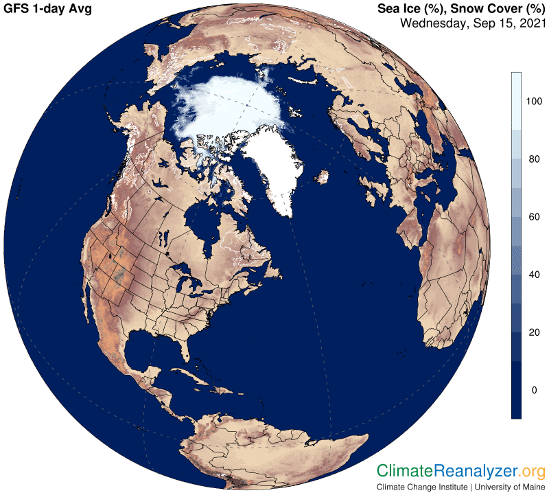
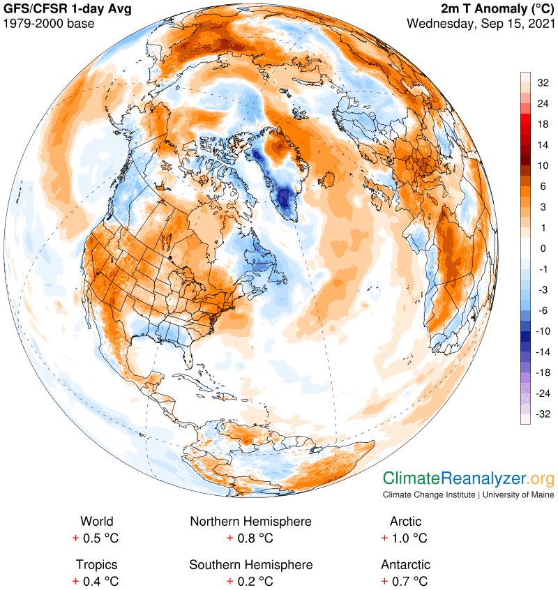
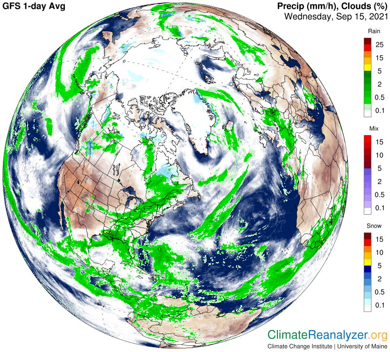
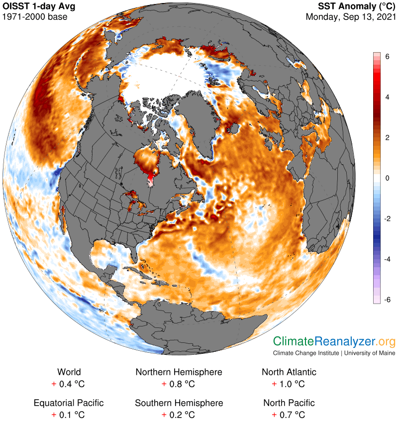
9/15/21 – Here’s the latest Arctic Data from Climate Reanalyzer
9/15/21 – Here are the latest Arctic Sea Ice Thickness models from the U.S. Navy
9/15/21 – Methane Report for CAMS & NOAA Data for Tuesday, 9/14/21 & Mid-Week Update
Margo also reads 1 Peter Chapter 4.
9/16/21 – Here’s the latest on the La Palma earthquakes and volcano situation from Volcano Discovery
La Palma Island (Canary Islands): earthquake swarm slows down
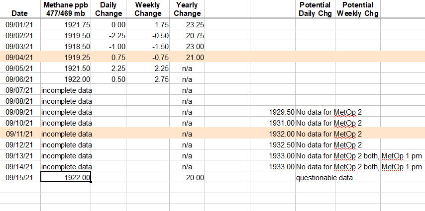
9/16/21 – NOAA has finally released methane data for all four satellite readings for 9/15/21. There is a lot of missing data (white areas). Even with that, it still averages to 1922.0 ppb, which is where we were on 9/6/21. I think it should be higher, but this is what we have.
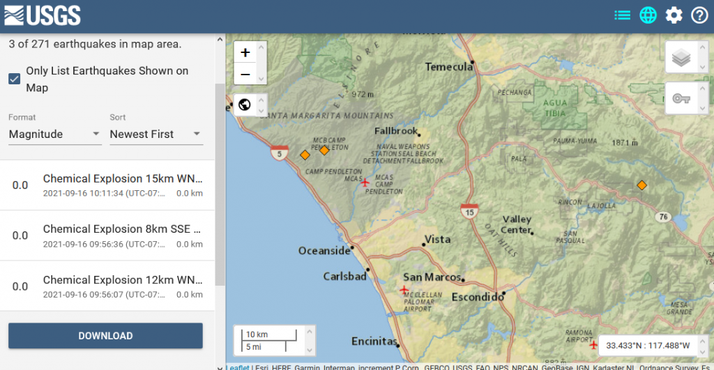
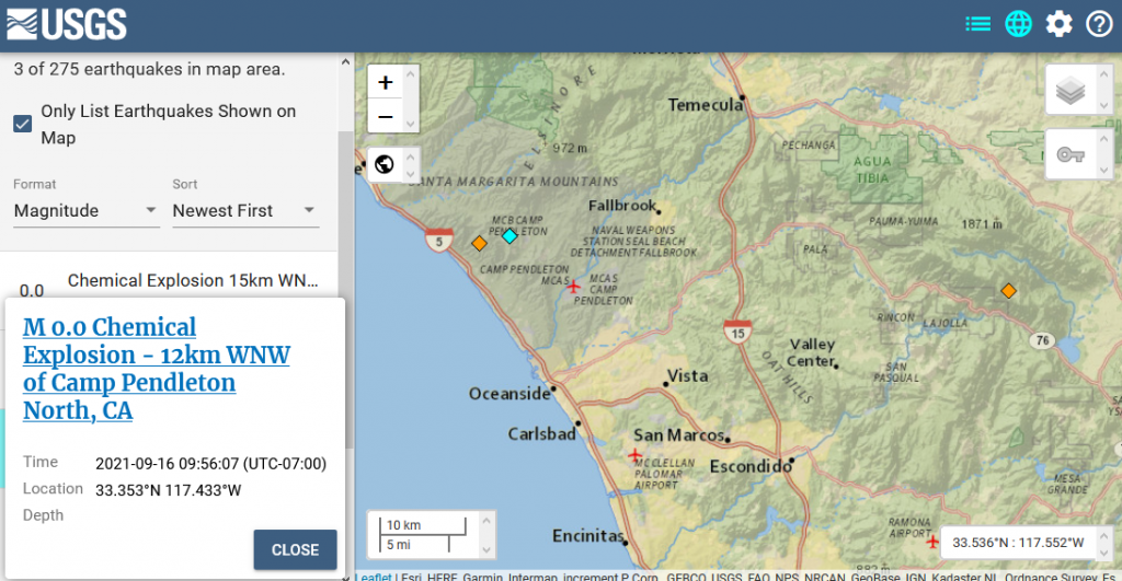
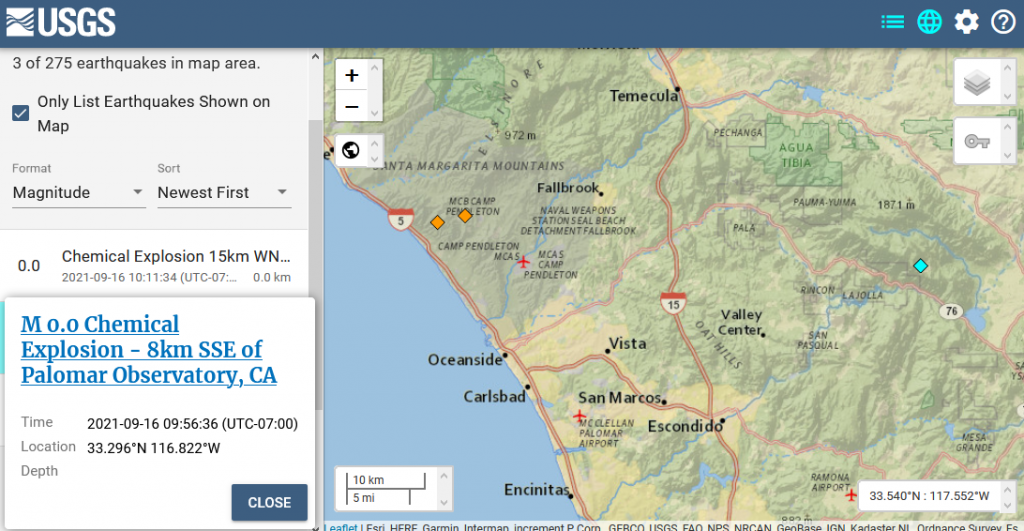
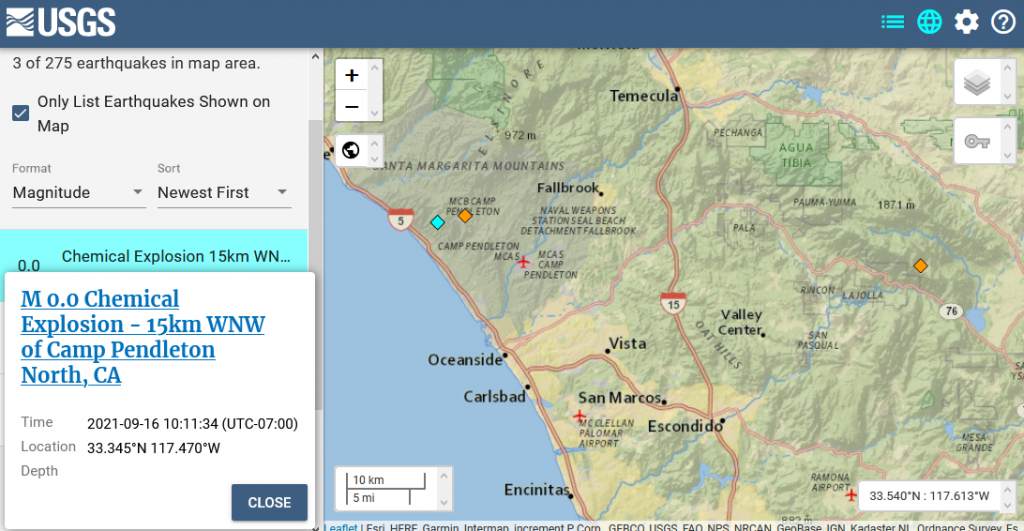
9/16/21 – Three Chemical Explosions occurred this morning in Southern California
M 0.0 Chemical Explosion – 12km WNW of Camp Pendleton North, CA
- 2021-09-16 16:56:07 (UTC)
- 33.353°N 117.433°W
- 0.0 km depth
M 0.0 Chemical Explosion – 8km SSE of Palomar Observatory, CA
- 2021-09-16 16:56:36 (UTC)
- 33.296°N 116.822°W
- 0.0 km depth
M 0.0 Chemical Explosion – 15km WNW of Camp Pendleton North, CA
- 2021-09-16 17:11:34 (UTC)
- 33.345°N 117.470°W
- 0.0 km depth
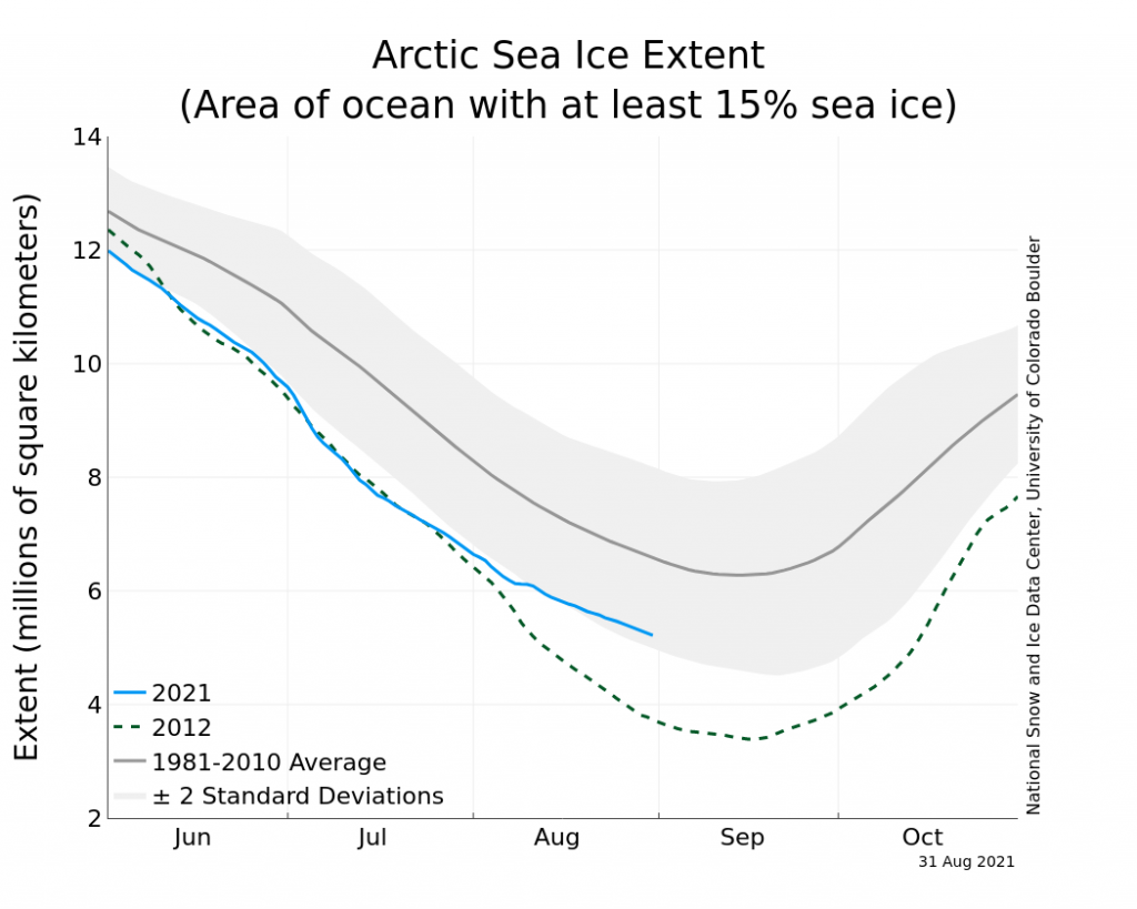
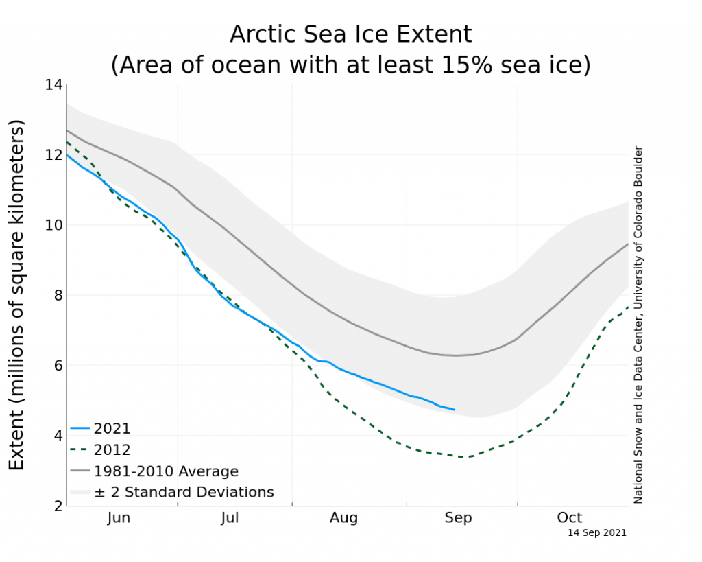
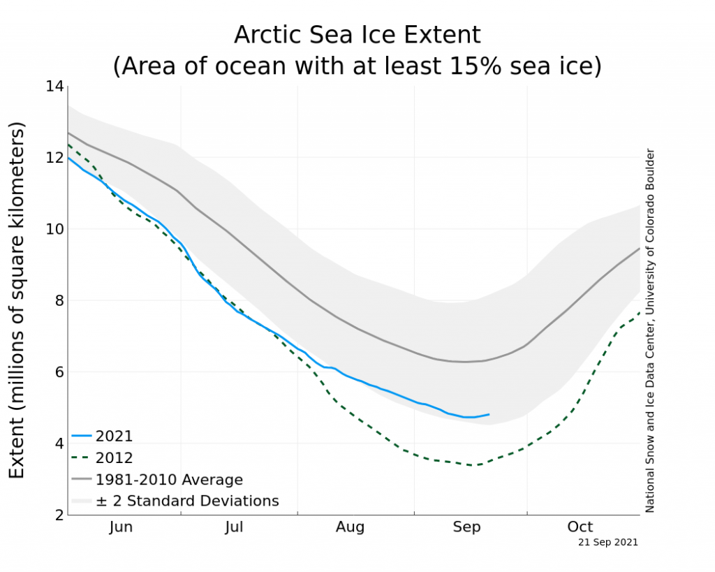
9/17/21 – An odd summer’s end
Here’s the report from the National Snow and Ice Data center on the Arctic sea ice.
“As of September 15, Arctic sea ice extent stood at 4.73 million square kilometers (1.83 million square miles), placing it tenth lowest in the satellite record for the date. While extent continues to decline as of this post, the seasonal minimum is likely to occur soon, depending on how much heat remains in the upper ocean and on winds, which can compact the ice cover or spread it out. If the winds push the ice poleward, this may further reduce the total extent. Nevertheless, the seasonal minimum extent promises to be one of the highest of the past decade—only 2013, 2014, and 2018 are currently tracking above the 2021 sea ice extent.”
https://nsidc.org/arcticseaicenews/2021/09/an-odd-summers-end/
9/17/21 – Methane Report for CAMS & NOAA Data for Wednesday & Thursday, 9/15-9/16/21 & Other Updates
Margo reviews the NSIDC’s latest report on the state of the Arctic sea ice. Margo also reads 1 Peter Chapter 5.
Show Link:
https://nsidc.org/arcticseaicenews/2021/09/an-odd-summers-end/
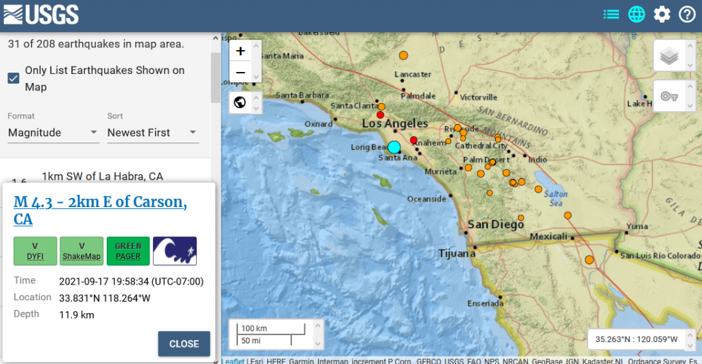
9/18/21 – 4.3 M Earthquake in the Los Angeles area last night
M 4.3 – 2km E of Carson, CA
- 2021-09-18 02:58:34 (UTC)
- 33.831°N 118.264°W
- 11.9 km depth
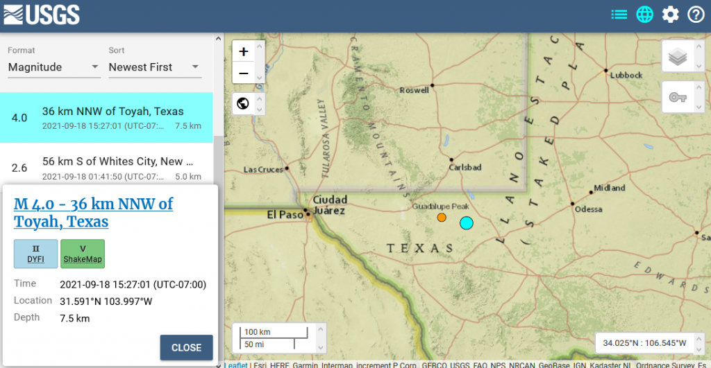
9/18/21 – 4.0 M Earthquake in West Texas today
M 4.0 – 36 km NNW of Toyah, Texas
- 2021-09-18 22:27:01 (UTC)
- 31.591°N 103.997°W
- 7.5 km depth
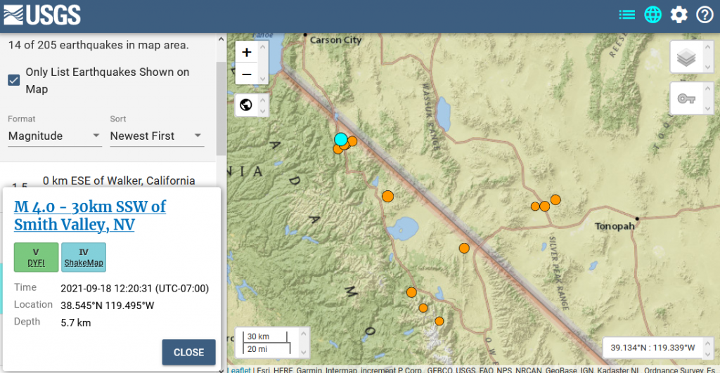
9/18/21 – 4.0 M Earthqake in the Coleville Swarm area today
M 4.0 – 30km SSW of Smith Valley, NV
- 2021-09-18 19:20:31 (UTC)
- 38.545°N 119.495°W
- 5.7 km depth
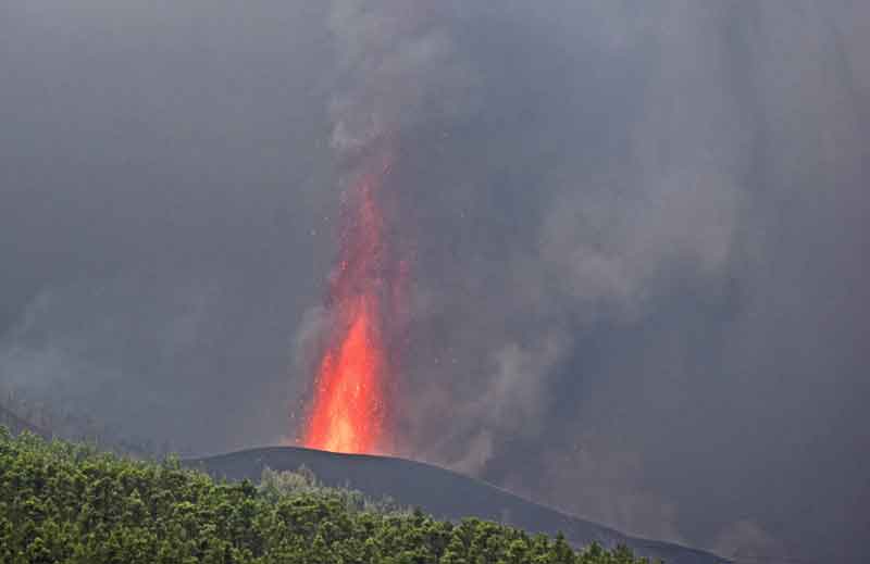
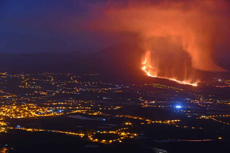
9/19/21 – After a 3.8 M earthquake, La Palma volcano has started erupting. Volcanic ash plumes are rising to 5,000 ft. (1,500 m.)
Here’s the link for the latest news on Volcano Discovery
https://www.volcanodiscovery.com/la-palma/news.html
LIVE: Volcano erupts on La Palma in the Canary Islands
9/19/21 – Methane Report for CAMS Data for Friday, 9/17/21
9/19/21 – La Palma volcano eruption update: lava flows cut road, threaten inhabited areas, evacuations ordered
The lava flows already crossed the Tacande highway at around 5.30 pm, making the passage of vehicles impractical. La Palma airport has also been closed during the first hours after the eruption, as ash plumes hindered visibility, but later resumed its operations as the ash emissions decreased again.
The alert status of the volcano was raised orange (3 out of 4), and the General Directorate of Security and Emergencies of the Government of the Canary Islands activated the level 2 emergency situation (red traffic light), in application of the Volcanic Risk Plan (Pevolca).
https://www.volcanodiscovery.com/la-palma/news/141863/La-Palma-volcano-eruption-update-lava-flows-cut-road-threaten-inhabited-areas-evacuations-ordered.html
9/19/21 – Looking at La Palma Volcano, Methane, Sea Ice & Climate Update with Margo (Sept. 19, 2021)
Margo reviews methane data from CAMS & NOAA for Saturday, 9/18/21. She also shows the current state of the Arctic and Antarctic sea ice and looks at Climate Reanalyzer and recent earthquakes. Margo covers the La Palma situation. Margo also reads 2 Peter Chapter 1.
Show Link:
https://www.volcanodiscovery.com/la-palma/news.html
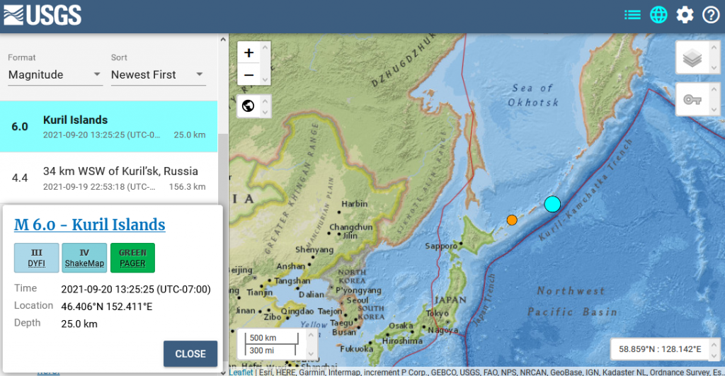
9/20/21 – 6.0 M Earthquake in the Kuril Islands
M 6.0 – Kuril Islands
- 2021-09-20 20:25:25 (UTC)
- 46.406°N 152.411°E
- 25.0 km depth
9/20/21 – La Palma volcano eruption update: new eruptive fissure opens, followed by strong magnitude 3.8 quake
As suspected as a possible scenario earlier, the eruption continues to evolve as a new fissure opened around 9 p.m. local time in the area of Tacande, in the municipality of El Paso. It seems to be approx. 1 km west of the original vents.
The opening of the new eruptive fissure was followed by a relatively strong magnitude 3.8 quake at 9.32 p.m., widely felt by people in Los Llanos de Aridane, Breña Baja, Tazacorte, El Paso, Breña Alta, Fuenca.
https://www.volcanodiscovery.com/la-palma/news/141970/La-Palma-volcano-eruption-update-new-eruptive-fissure-opens-followed-by-strong-magnitude-38-quake.html
9/21/21 – Cumbre Vieja volcano eruption, La Palma: increasing tremor, lava flows destroy town of Todoque
The eruption continues with lava fountains from the new vent that opened last night and continuing lava flow emission. During the past hours, volcanic tremor has increased significantly, suggesting that output rate has increased or something else is changing. It will probably become clearer in the next hours what is happening.
https://www.volcanodiscovery.com/la-palma/news/142049/Cumbre-Vieja-volcano-eruption-La-Palma-increasing-tremor-lava-flows-destroy-town-of-Todoque.html
9/21/21 – CAMS is showing high sulfur dioxide from La Palma and also the Aleutian Islands from another volcanic eruption from Semisopochnoi.
source: CAMS Sulfur Dioxide for 9/21/21, Global View, Total Column; North Pole View, Total Column & 500 hpa
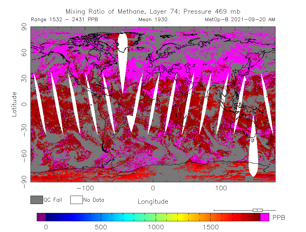
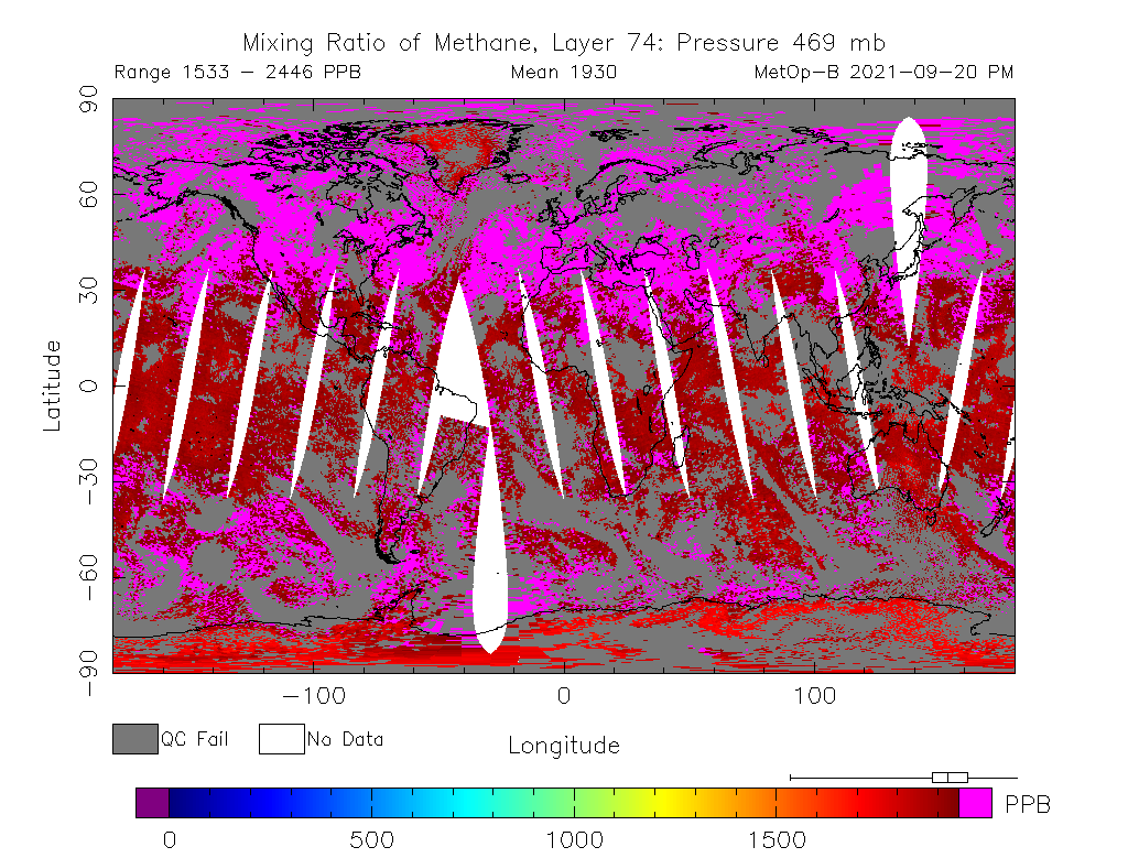
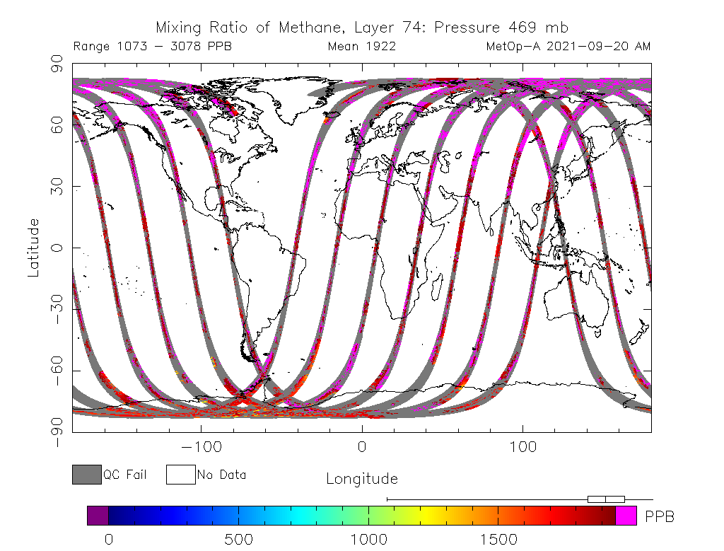
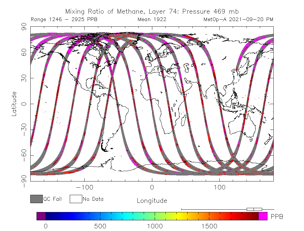
9/21/21 – NOAA has posted methane data for all four readings for two days. However, I’m not sure how to interpret the data. The MetOp 2 satellite is missing so much data in weird patterns I haven’t seen before. Here are the images from yesterday, 9/20/21.
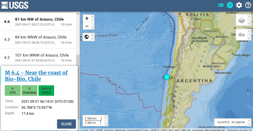
9/21/21 – 6.4 M Earthquake Chile
M 6.4 – Near the coast of Bio-Bio, Chile
- 2021-09-21 13:14:31 (UTC)
- 36.788°S 73.957°W
- 17.4 km depth
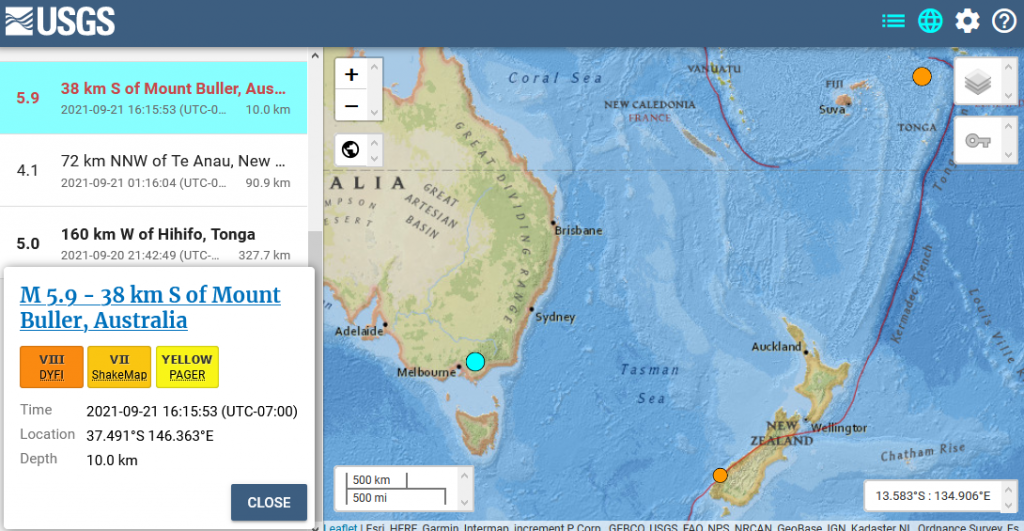
9/21/21 – 5.9 M Earthquake Australia
M 5.9 – 38 km S of Mount Buller, Australia
- 2021-09-21 23:15:53 (UTC)
- 37.491°S 146.363°E
- 10.0 km depth
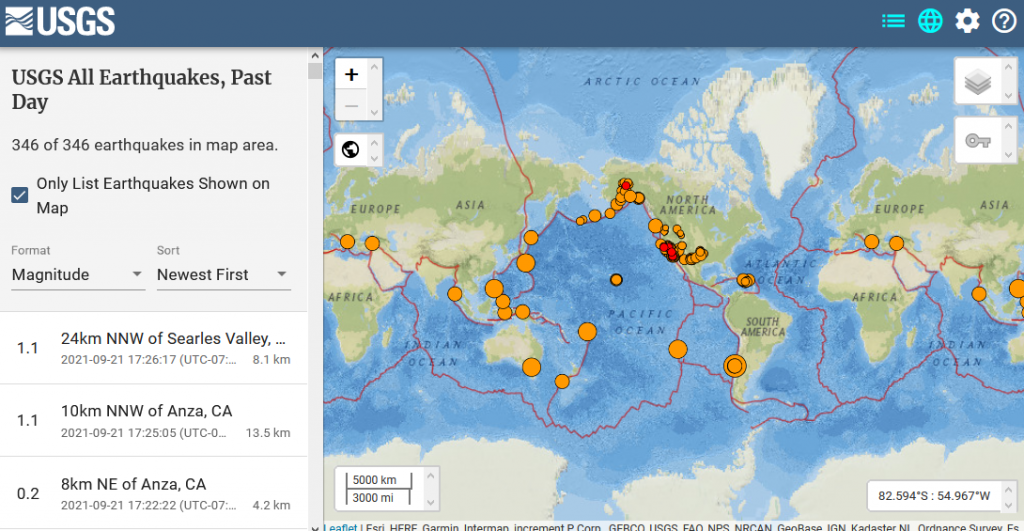
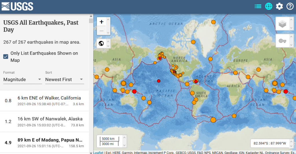
9/21/21 – 346 Earthquakes Worldwide Today
NOTE: The earthquakes from La Palma are not included in this image
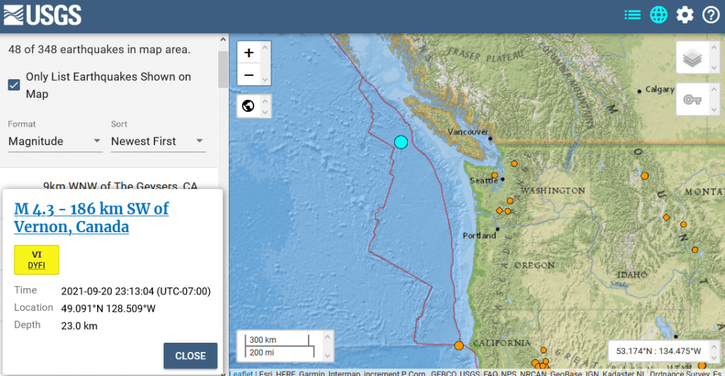
9/21/21 – 4.3 M Earthquake on the north end of the Juan de Fuca plate
M 4.3 – 186 km SW of Vernon, Canada
- 2021-09-21 06:13:04 (UTC)
- 49.091°N 128.509°W
- 23.0 km depth
9/21/21 – Methane Report for CAMS for Sunday, 9/19/21 & NOAA for Sunday & Monday, 9/19-9/20/21 & Other Updates
Margo also reads 2 Peter 2.
Show Links:
https://www.volcanodiscovery.com/la-palma/news.html
https://www.volcanodiscovery.com/semisopochnoi/news.html
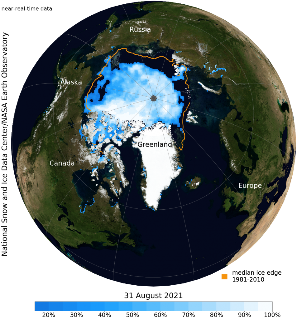
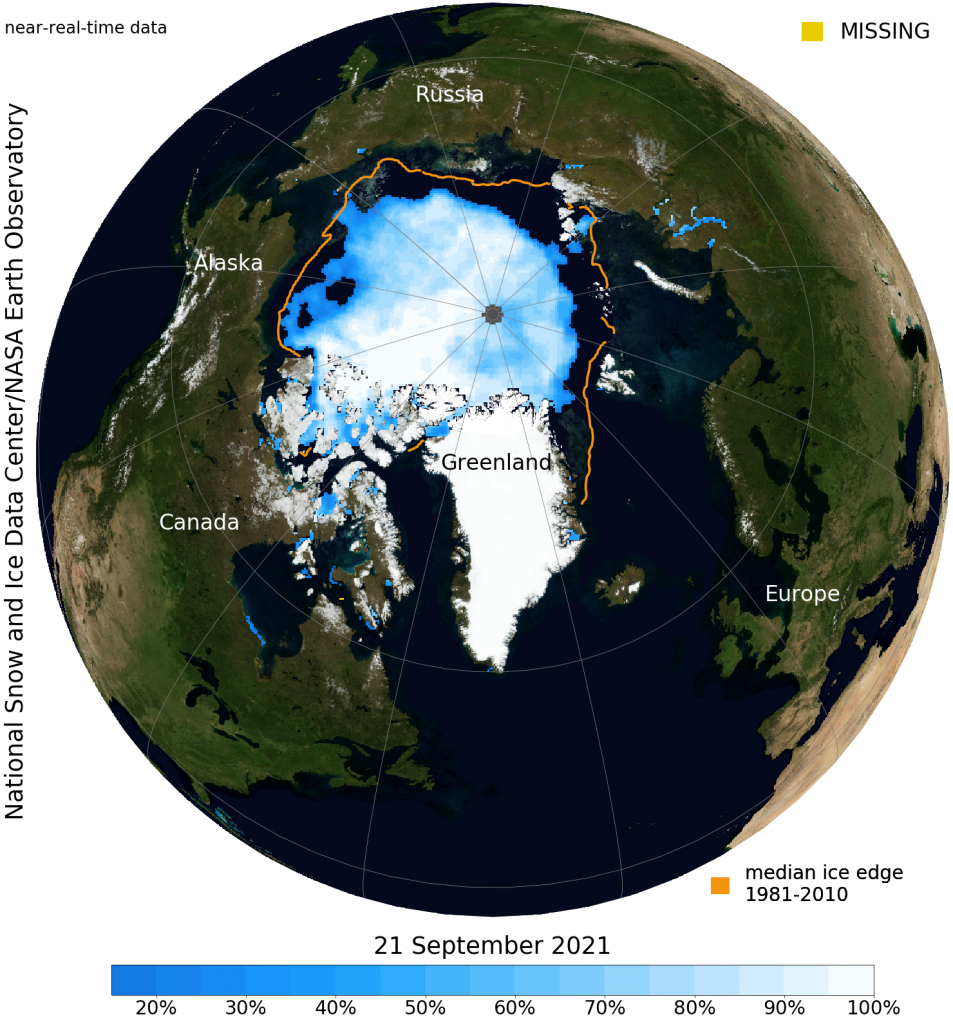
9/22/21 – Arctic sea ice has reached minimum extent for 2021
Arctic sea ice has likely reached its minimum extent for the year, at 4.72 million square kilometers (1.82 million square miles) on September 16, 2021, according to scientists at the National Snow and Ice Data Center (NSIDC) at the University of Colorado Boulder. The 2021 minimum is the twelfth lowest in the nearly 43-year satellite record. The last 15 years are the lowest 15 sea ice extents in the satellite record.
https://nsidc.org/news/newsroom/arctic-sea-ice-has-reached-minimum-extent-2021
https://twitter.com/i/status/1440697225982607360
9/22/21 – La Palma volcano update: New vent opens, Tacande village evacuated
Activity continued to increase overall. During the course of the morning, two more fissures opened, one close to the original ones and another one further north of the existing vents, southeast of Tacande village, which was evacuated soon after. The opening of the vent followed rapid ground inflation in this area of 15 cm, according to unconfirmed information.
Most activity now seems to occur from the Tacande vent. It is well visible from the highway LP3 when going west after exiting the tunnel and attracts many tourists and locals alike to watch. Already, an elongated cinder cone has formed around it, and continuous lava fountains have been rising to approx. 2-300 m or more in height, producing a steam and ash plume that was rising approx. 2000 m and visible when we approached the island by airplane.
Our local correspondents who helped in recovery operations to save household items from threatened homes down from the active lava flow fronts, reported heavy ash fall in the downwind areas to the SW.
The lava flow fronts, often exceeding 10 m in height, slowed down further today but continue to widen; the largest one remains in the center of Todoque where more houses have fallen victim to the lava.
In total, the eruption has destroyed more than 320 homes and covered over 140 hectares of land by lava flows so far.
https://www.volcanodiscovery.com/la-palma/news/142192/La-Palma-volcano-update-New-vent-opens-Tacande-village-evacuated.html
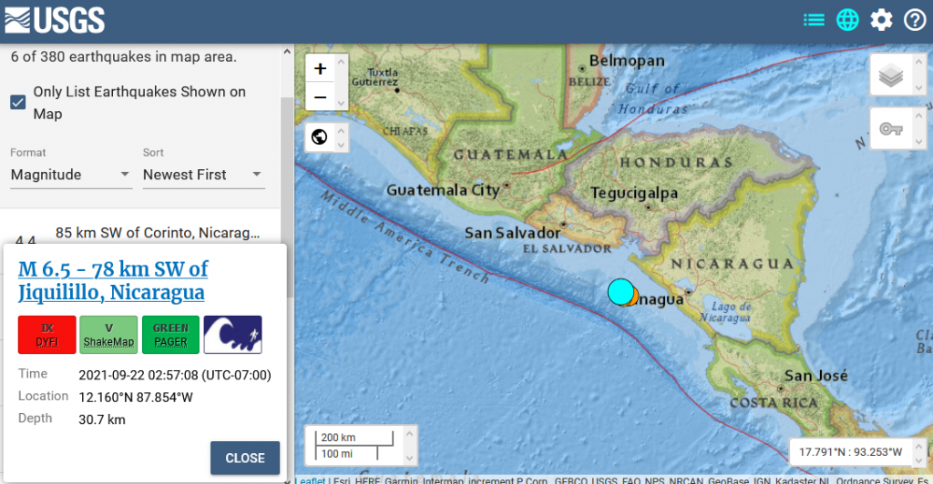
9/22/21 – 6.5 M Earthquake off the west coast of Nicaragua
M 6.5 – 78 km SW of Jiquilillo, Nicaragua
- 2021-09-22 09:57:08 (UTC)
- 12.160°N 87.854°W
- 30.7 km depth
9/22/21 – NSIDC Arctic Sea Ice as of yesterday
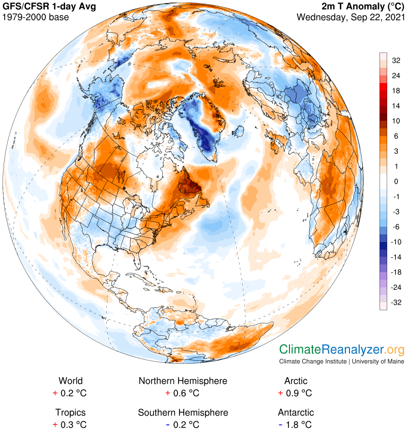
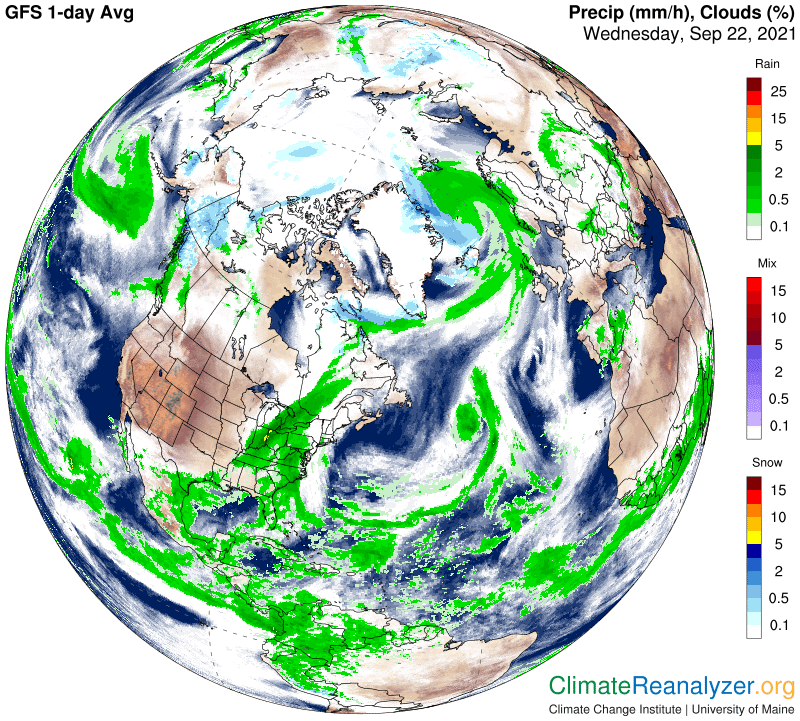
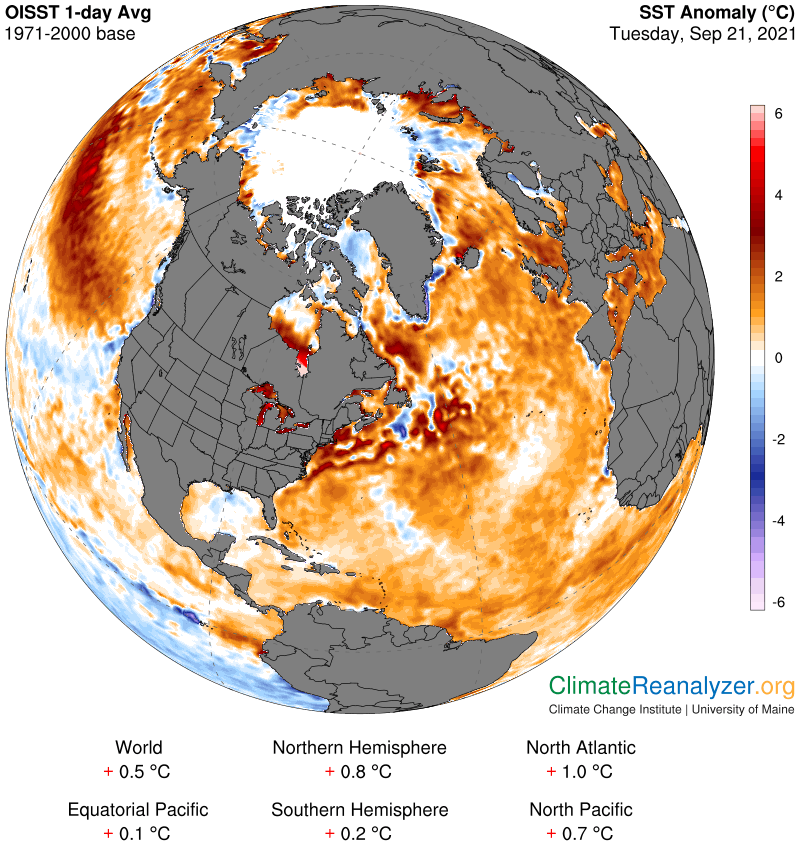
9/22/21 – Here’s the latest Arctic Data from Climate Reanalyzer

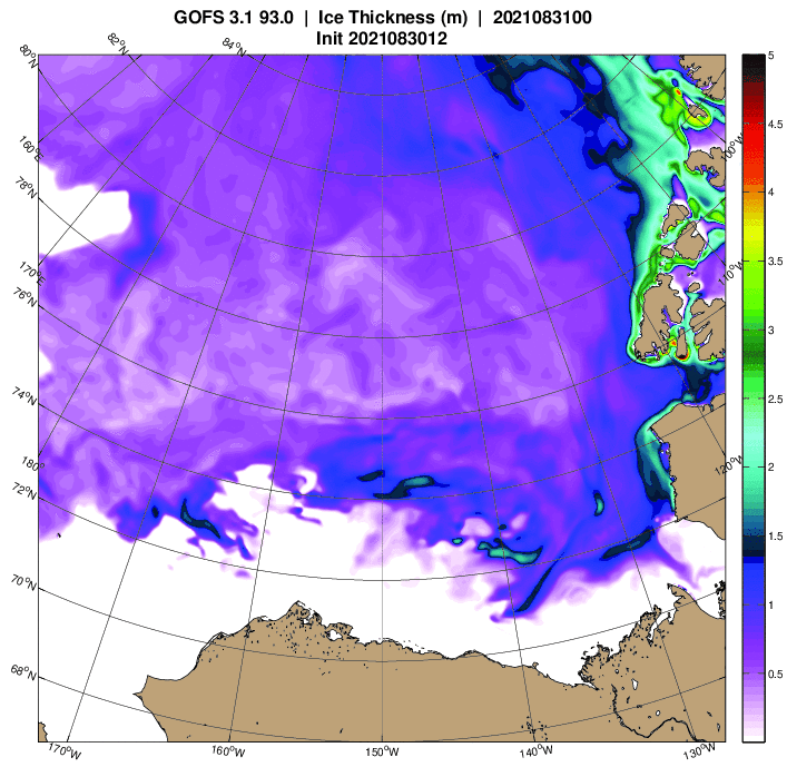
9/22/21 – Here are the latest Arctic Sea Ice Thickness models from the U.S. Navy


9/22/21 – Methane Report for NOAA Data for Tuesday, 9/21/21 & Mid-Week Update
Margo shares the NSIDC press release on the Arctic sea ice minimum for this year and updates on the La Palma situation. Margo also reads 2 Peter Chapter 3.
Show Links:
https://www.volcanodiscovery.com/la-palma/news.html
https://nsidc.org/news/newsroom/arctic-sea-ice-has-reached-minimum-extent-2021
9/23/21 – Methane Report for CAMS Data for Monday, 9/20/21
9/24/21 – La Palma volcano update: Increasing explosive activity, powerful shock waves
Explosions have increased during the past hours, often generating shock powerful waves that can break glass in up to 3 km distance. A new effusive vent has been reported to have opened on the flank of the main cone.
As a reaction to the increase in explosive activity, new evacuations have been ordered for the areas of Tajuya and the remaining parts of Tacande.
https://www.volcanodiscovery.com/la-palma/news/142336/La-Palma-volcano-update-Increasing-explosive-activity-powerful-shock-waves.html
9/24/21 – Boots on the ground in La Palma
It gets worse. More lava. More people evacuated. It´s sad! Live News from La Palma Volcanic Eruption
9/24/21 – Methane Report for CAMS Data for Tuesday, 9/21/21
9/24/21 – Methane Report for CAMS Data for Wednesday, 9/22/21
9/24/21 – Methane Report for CAMS for Thursday, 9/23/21 & NOAA for Wednesday & Thursday, 9/22-9/23/21 & Other Updates
Margo also reads 1 John Chapter 1.
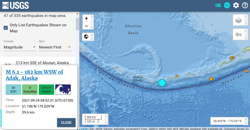
9/25/21 – 6.1 M Earthquake in the Aleutian Islands yesterday
M 6.1 – 182 km WSW of Adak, Alaska
- 2021-09-24 11:52:31 (UTC)
- 51.196°N 179.029°W
- 39.6 km depth
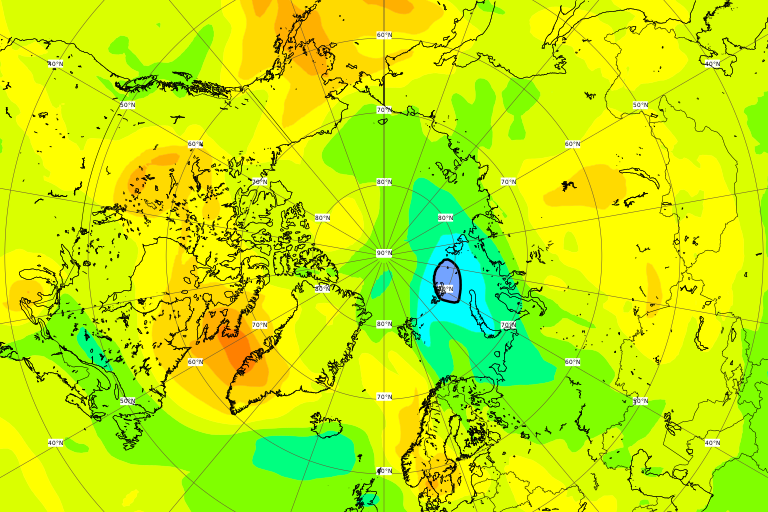
9/25/21 – An ozone hole opened up briefly over the Arctic on Thursday
source: CAMS Ozone for 9/23/21 Arctic View, Total Column
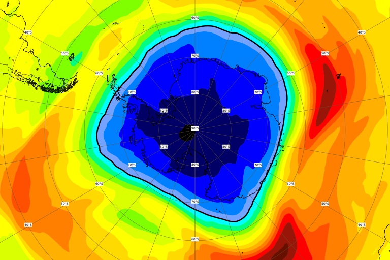
9/25/21 – Here’s the ozone hole over the Antarctic yesterday. The complete continent is in the danger zone with the thinnest area in the black next to the South Pole, 100-125 du.
source: CAMS Ozone for 9/24/21, Antarctic View, Total Column
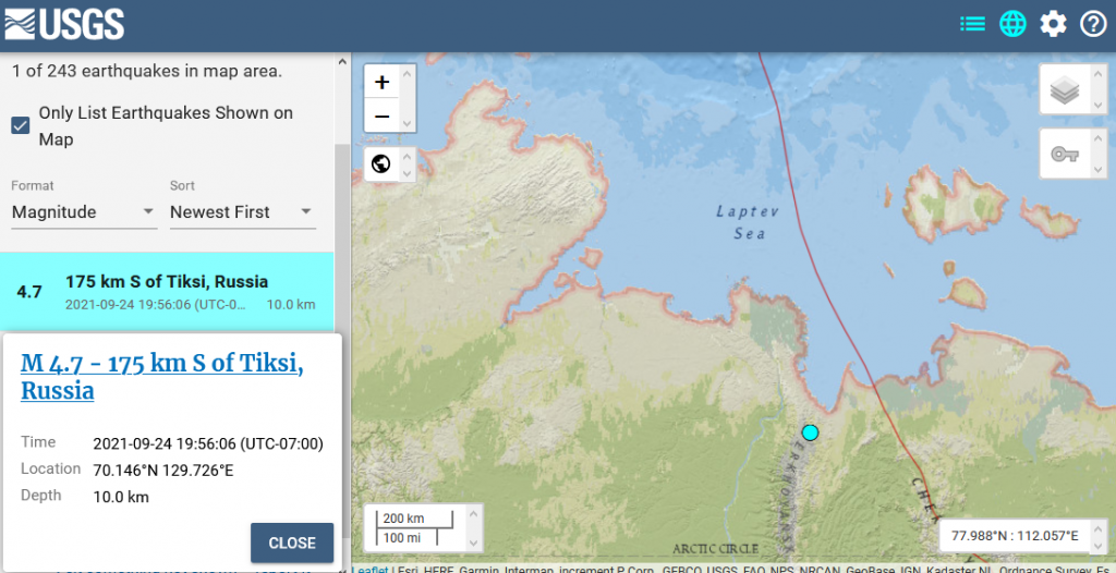
9/25/21 – 4.7 M Arctic earthquake in Northern Russia near the Laptev Sea
M 4.7 – 175 km S of Tiksi, Russia
- 2021-09-25 02:56:06 (UTC)
- 70.146°N 129.726°E
- 10.0 km depth
9/25/21 – Cumbre Vieja volcano (La Palma): eruption continues with strong lava fountains, lava flow and ash emissions
https://www.volcanodiscovery.com/la-palma/news/142413/La-Palma-volcano-update-.html
9/25/21 – Methane Report for CAMS & NOAA Data for Friday, 9/24/21, La Palma & Other Updates
Margo also reads 1 John Chapter 2.
9/26/21 – Cumbre Vieja volcano eruption, La Palma, activity update and field report: western portion of crater collapsed
The eruption continues at fluctuating intensity and with significant changes at the morphology of the new crater:
During the course of yesterday, a significant portion of the western flank of the cone collapsed, likely during a series of rockfalls, leaving a narrow horse-show shaped breach, thus lowering the main vent, which continued to produce violent pulsating lava fountains at fluctuating intensity.
During periods, the jets of lava likely surpassed 500 m in height with individual bombs reaching perhaps up to around 1000 m in height. Jets usually were more or less vertical, but sometimes also oblique to the west, suggesting the presence of at least two closely-spaced vents.
The lava flow from the effusive vent on the NW flank of the cone seemed to almost cease during the evening, but later resumed, creating a new flow in the same channel. This lava flow was still active by the time we left the scene at around 10 a.m.
https://www.volcanodiscovery.com/la-palma/news/142495/Cumbre-Vieja-volcano-eruption-La-Palma-activity-update-and-field-report-western-portion-of-crater-co.html
Violent spattering could be seen at the vent; the following video shows the high fluidity of the erupted lava:
9/26/21 – 267 EQs Worldwide today
Note the 3 Arctic earthquakes around Greenland
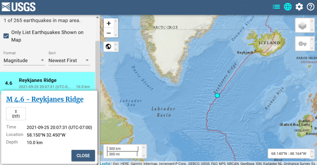
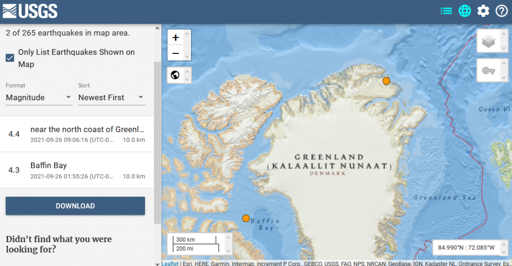
9/26/21 – Three Arctic earthquakes around Greenland today
M 4.6 – Reykjanes Ridge
- 2021-09-26 03:07:31 (UTC)
- 58.150°N 32.450°W
- 10.0 km depth
M 4.3 – Baffin Bay
- 2021-09-26 08:55:26 (UTC)
- 73.986°N 73.397°W
- 10.0 km depth
M 4.4 – near the north coast of Greenland
- 2021-09-26 16:06:16 (UTC)
- 82.955°N 25.298°W
- 10.0 km depth
9/26/21 – Methane, Sea Ice & Climate Roundup with Margo (Sept. 26, 2021)
Margo reviews methane data from CAMS & NOAA for Saturday, 9/25/21. She also shows the current state of the Arctic and Antarctic sea ice and looks at Climate Reanalyzer and recent earthquakes. Margo shows the latest developments on the La Palma situation. Margo also reads 1 John Chapter 3.
Show Links:
https://www.volcanodiscovery.com/la-palma/news.html
https://nsidc.org/news/newsroom/arctic-sea-ice-has-reached-minimum-extent-2021
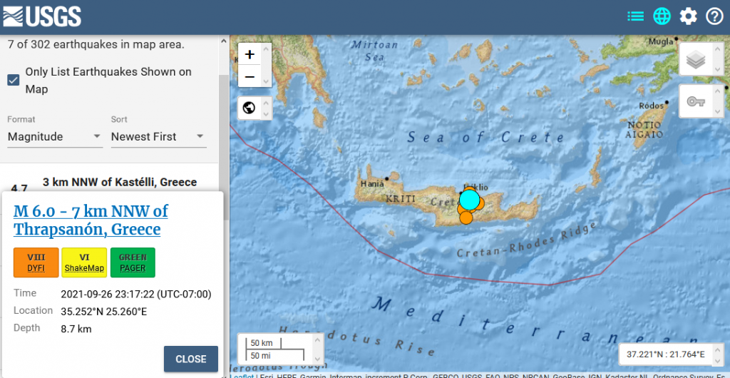
9/27/21 – 6.0 M Earthquake on Crete
M 6.0 – 7 km NNW of Thrapsanón, Greece
- 2021-09-27 06:17:22 (UTC)
- 35.252°N 25.260°E
- 8.7 km depth
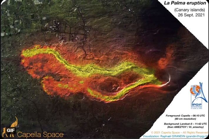
9/27/21 – La Palma volcano update: Cumbre Vieja volcano eruption, La Palma: thermal image reveals two lava flows
According to CAPELLA and Landsat-8 infrared detection system, two lava flows were revealed and detected in satellite images from 26 September.
https://www.volcanodiscovery.com/la-palma/news/142585/La-Palma-volcano-update-Cumbre-Vieja-volcano-eruption-La-Palma-thermal-image-reveals-two-lava-flows.html
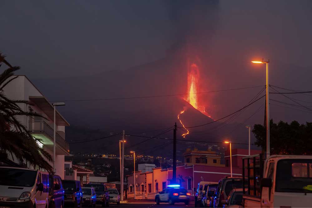
9/27/21 – Cumbre Vieja volcano eruption, La Palma: villages under curfew as lava flows come closer to the sea
According to the national TV station RTVE, eruptive resumed later this morning with emissions of steam and ash, although we cannot confirm this. Live cameras show little activity so far and tremor remains very low at the time of this update. A friend near the eruptive site this morning could not see any activity at the vents.
Yesterday, the lava had formed a new, narrower lobe emerging from the broad main front (coming from the main source, corresponding to the original flows), that had advanced at fast pace of about 100 m per hour eastwards. At the same time, the lava flow from the secondary fissure vent at the NW base of the cone continued to form its own flow, which had been advancing along the northern margin of the main flow at approx. 30 meters per hour.
The main flow had passed village of Todoque and destroyed the church of San Pio X, and was located only about 1.6 km from the sea. As a precaution to an expected sea entry in the near future, authorities ordered curfew for the localities of San Borondón, Marina Alta, Marina Baja and La Condesa, where people were not allowed to leave their homes and should keep windows and doors closed.
SO far, lava flows have destroyed more than 450 buildings and covered an area of 212.1 hectares.
The situation is clearly evolving and we will post updates later when returning from the field.
https://www.volcanodiscovery.com/la-palma/news/142593/Cumbre-Vieja-volcano-eruption-La-Palma-villages-under-curfew-as-lava-flows-come-closer-to-the-sea.html
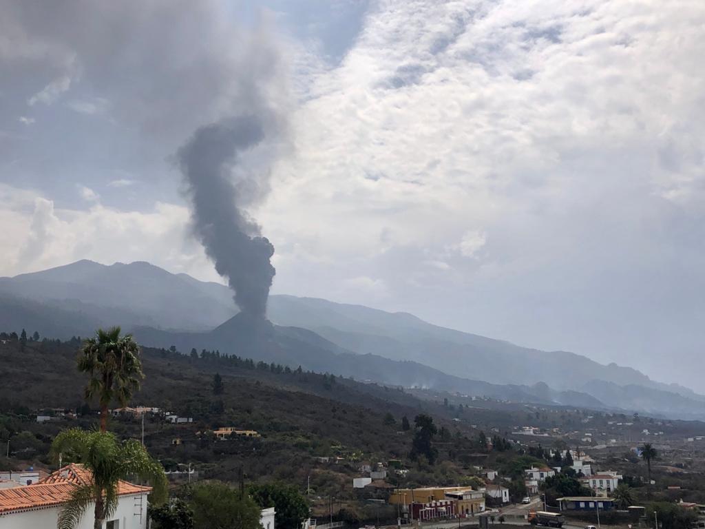
9/27/21 – La Palma volcano update: Intermittent ash emissions
Activity is picking up again. The volcano has been producing intermittent explosions with ash emissions from the new cone, at intervals of roughly every 10 minutes.
https://www.volcanodiscovery.com/la-palma/news/142602/La-Palma-volcano-update-Intermittent-ash-emissions.html
9/28/21 – Arctic Ozone Hole Opened Up in the North Atlantic & Barents Sea Today (9/28/21)
9/28/21 – Methane Report for CAMS & NOAA Data for Sunday & Monday, 9/26-9/27/21, La Palma & Earthquakes
Margo also reads 2 John Chapter 1.
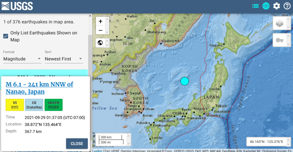
9/29/21 – 6.1 M Earthquake west of Japan
M 6.1 – 241 km NNW of Nanao, Japan
- 2021-09-29 08:37:05 (UTC)
- 38.872°N 135.464°E
- 367.7 km depth
9/29/21 – NSIDC Arctic Sea Ice as of yesterday
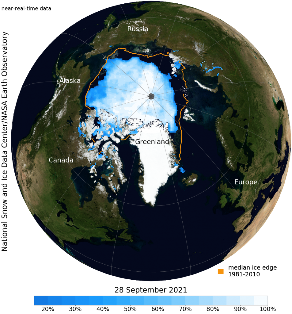

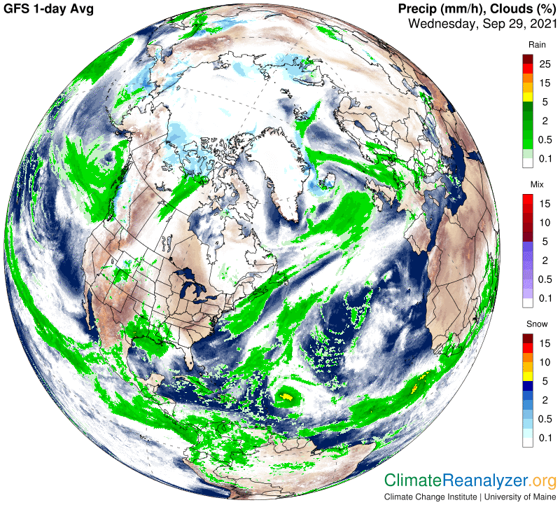
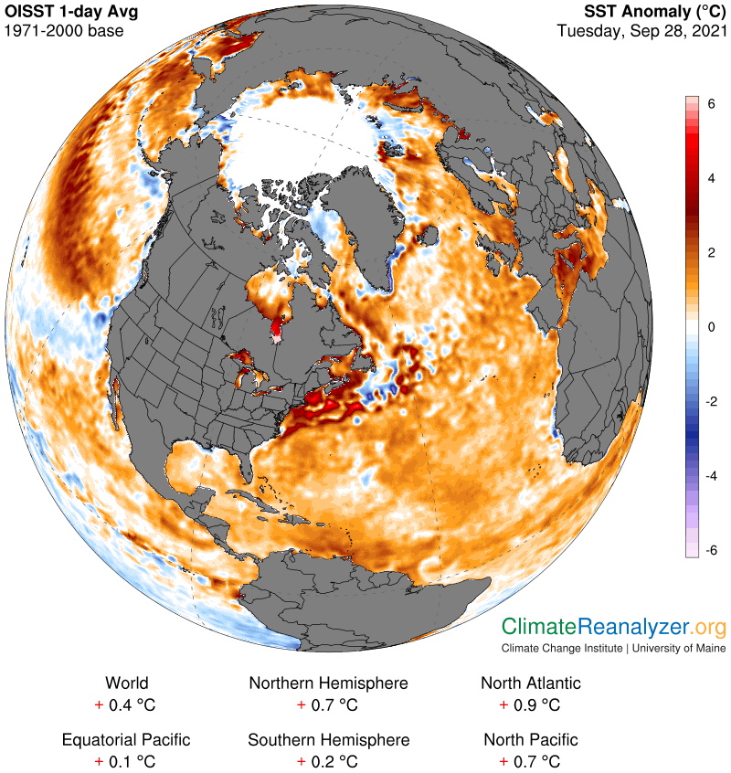
9/29/21 – Here’s the latest Arctic Data from Climate Reanalyzer
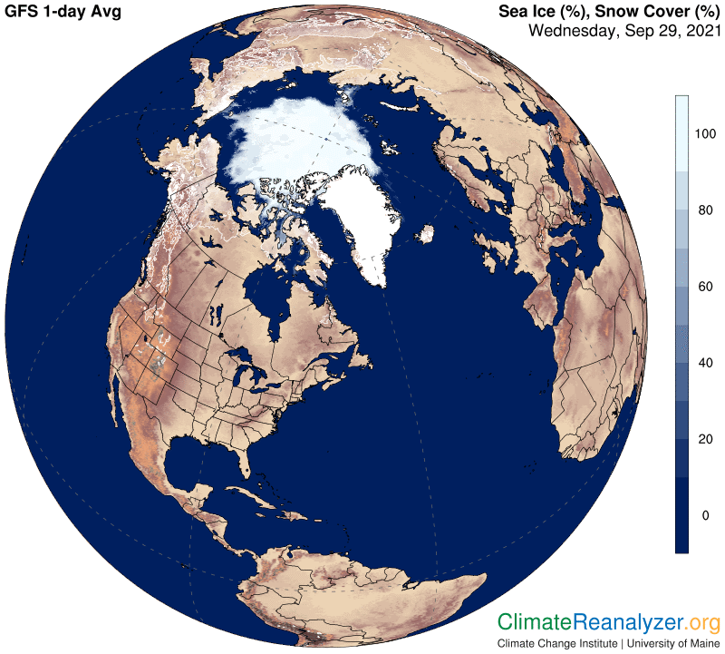
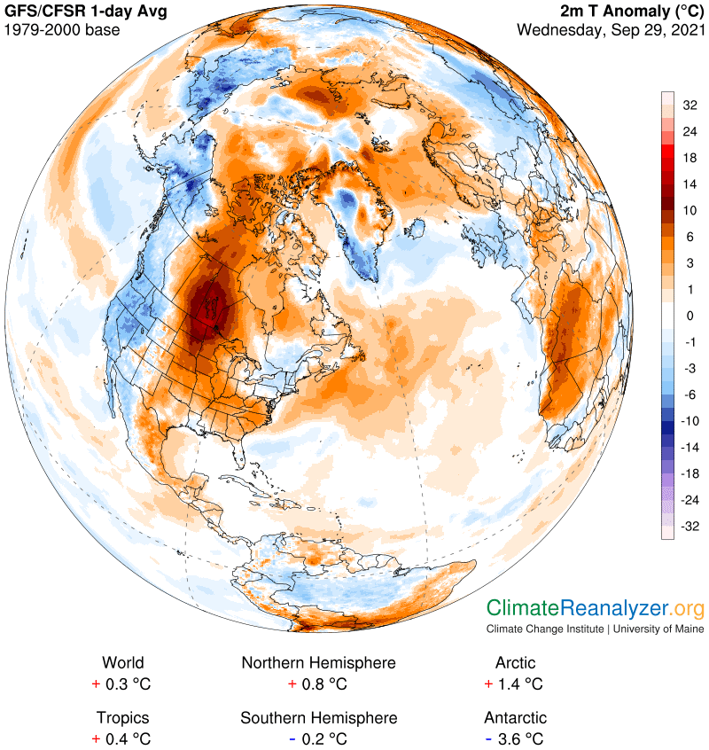
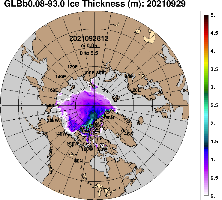
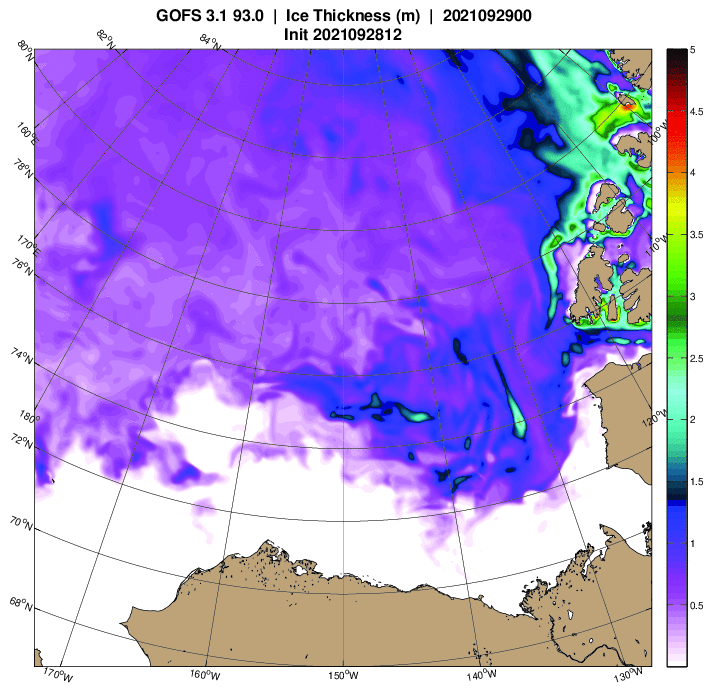
9/29/21 – Here are the latest Arctic Sea Ice Thickness models from the U.S. Navy

9/29/21 – Methane Report for CAMS & NOAA Data for Tuesday, 9/28/21 & Mid-Week Update
Margo also reads 3 John Chapter 1.
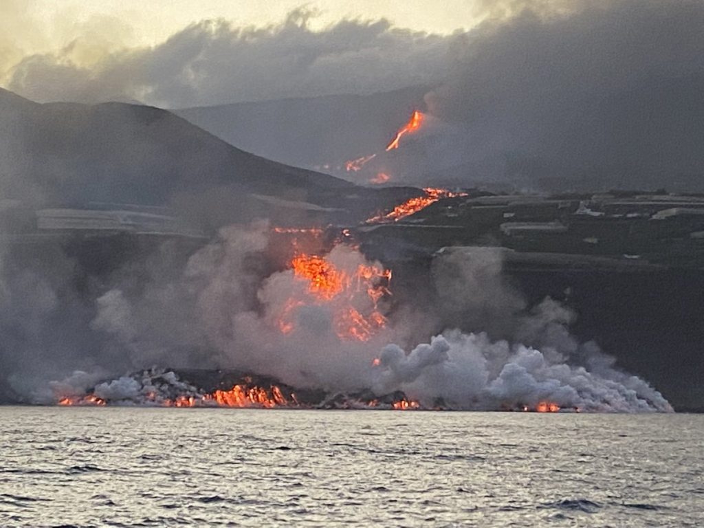
9/29/21 – La Palma volcano, Canary Islands: lava flows enter Atlantic ocean
Late last night, the lava flow reached the sea.
As the eruption continues to effuse lava at steady rate, the most advanced lava flow made rapid advance it seems during yesterday. It looks that it traveled approx. 1 km, passing north of the cinder cone of Montana Todoque to arrive and descend at the sea cliff at Playa Nueva.
The nearby coastal areas have been evacuated as the sea entry can generate acid clouds of hot steam and there is always risk of collapse of the material at the newly formed lava beach bench.
https://www.volcanodiscovery.com/la-palma/news/142762/La-Palma-volcano-Canary-Islands-lava-flows-enter-Atlantic-ocean.html